Macomb’s Dam Bridge

Macomb's Dam Bridge and the Harlem River Drive
Macomb’s Dam Bridge and the Harlem River Drive

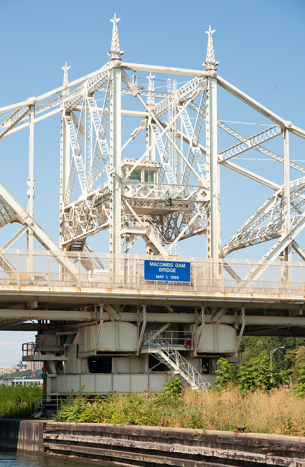
Crosses: Harlem River
Connects: Washington Heights, Manhattan and Grand Concourse, Bronx, NY [satellite map]
Carries: 4 vehicular lanes, 2 sidewalks
Design: swing
Date opened: May 1, 1895
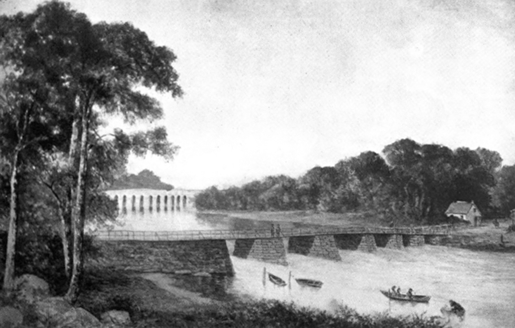
Postcard view: “Viaduct 155th Street, New York City.”

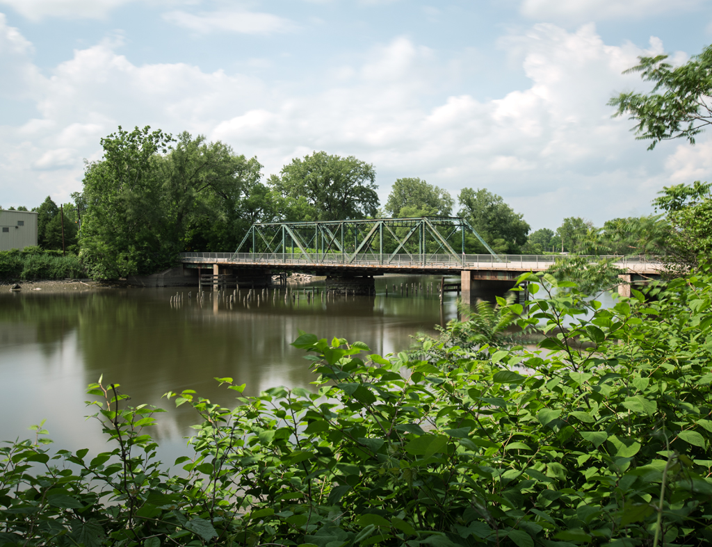
Macomb’s Dam bridge crosses the Harlem River, connecting West 155th Street in Manhattan with Jerome Avenue in the Bronx, just west of Yankee Stadium.

The Dam

Sign warning of gong signaling bridge opening

The story of Macomb’s Dam Bridge dates back to 1813 when Robert Macomb, a local businessman, sought permission from the state legislature to build a dam across the Harlem River near 155th Street in Manhattan. He intended to turn the portion of the river between there and a dam he owned near King’s Bridge on Spuyten Duyvil Creek into a mill pond. The legislature granted permission for the dam on January 10, 1814, with a stipulation that a lock or some other mechanism for naval passage be built into the structure. In late 1813, when it became apparent that Macomb would be given permission to build his dam, a group of fifty prominent citizens petitioned the city’s Common Council seeking authorization for a bridge to be built on top of the dam. The petition mentioned Macomb’s approval for the idea, and an agreement to allow Macomb to charge tolls for passage over the bridge, with half of the toll money going to the city to help educate the poor. The Common Council announced the completion of the bridge on July 8, 1816, and recommended that the city build new roads in the area, which at the time was largely undeveloped, to take advantage of the new crossing.

When the dam was built, Macomb had a small lock, about 7 feet by 7 feet wide, installed on the Westchester County (encompassing what is now the Bronx) side of the structure. However, for unknown reasons, it was filled in with stone sometime in the late 1820s. For a while it was still possible for very small boats to pass through the openings between the piers supporting the bridge deck at high tide, but the trip was extremely hazardous. Several deaths were recorded when boats either overturned or broke apart during the passage.

Local citizens who had previously used the shores of the river for shipping coal, produce, and other materials began to organize an opposition to the obstruction caused by the dam. Robert Macomb had gone out of business by this point, and the ownership of the dam had passed through a number of hands. Complaints filed with the owners of the dam went nowhere, and the group enlisted the help of a young Lewis G. Morris.

The Nonpareil

Morris was of the belief that the obstruction of river navigation was illegal, so he devised a meticulous plan to reopen the river to traffic. He collected sworn statements from locals who had lived on the river before the construction of the dam, describing sloops and schooners sailing up the river to deliver cargo. Several times in early 1838, Morris took sail boats smaller than those described by the locals up the river to the dam, keeping detailed logs of the date, time, and the conditions of the water during the trip. Each time he reached the dam, he requested passage from the bridge tender. Each time, the bridge tender would turn him away, precisely as Morris expected, as such passage was impossible. On the night of September 14, 1838, Morris arranged for a shipment of coal to be delivered from Jersey City on board a boat named the Nonpareil to a dock he had built north of the dam in preparation for the plan. When the Nonpareil, with Morris aboard, reached the dam, passage through the dam was requested. Once again, the bridge tender refused to allow Morris through. When he did so, a band of about 100 men that had accompanied the Nonpareil on the last leg of her journey in an assortment of skiffs and flatboats went at the dam with shovels, axes, and other tools, tearing down a large enough section of the dam to allow Morris’ boat to pass through. When it was found that the tidal flow through the new opening was still difficult to navigate at anything but slack tide, the group returned the next week and spent three days tearing down additional sections of the dam.

Original bridge (Source: Harlem River Bridges)

William Renwick, the owner of the dam at the time, was furious, and attempted to have Morris arrested for disturbing the peace. When that failed, Renwick sued Morris for damages incurred to his property. In the Superior Court, Morris presented in his defense the original charter for the dam with its stipulation to allow navigation and the evidence he had collected showing that navigation, while once possible, was no longer so on account of the dam owner’s refusal. The court ruled that Morris had done nothing wrong. Renwick appealed the decision, and the Court of Errors affirmed the earlier decision. The case then went to the New York Supreme Court, where Justice J. Cowen ruled that the dam owners “have been guilty of a public nuisance” by obstructing the river with the dam. Having succeeded with his plan, Morris continued to act as an advocate for navigation and the improvement of the Harlem River, playing a major part in the construction of the High Bridge to carry the Croton Aqueduct over the river, the creation of the Harlem River Ship Canal, and other projects.

Central Bridge

After the lengthy legal battle, the owners found themselves forced to maintain an opening in the dam. This arrangement worked for a while, but increasing traffic on the river caused many to call for the complete destruction of the dam, and to have it replaced with a proper movable bridge. On April 16, 1858, the City of New York and Westchester County were directed by the state legislature to remove the dam and build a free public bridge with a turntable opening, allowing navigation of the river at any time of the day. Lewis G. Morris and Charles Bathgate, a local landowner, were appointed as commissioners to direct the project. In 1861, Central Bridge, as it was named by the city, was completed.

1861 square frame bridge (Source: Harlem River Bridges)
1861 square swing frame bridge (Source: Harlem River Bridges)

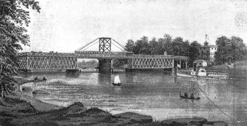
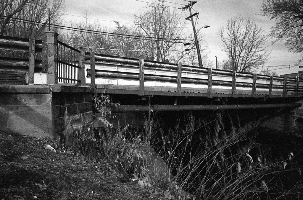
Central Bridge was a wooden structure requiring frequent repairs. Large portions of the bridge had to be rebuilt entirely. The square swing frame was replaced by a wooden “A” frame in 1877. The wooden approach spans were replaced by iron spans in 1883. These repairs did not seem to help much, as an 1885 New York Times article showed. “They ought to keep it for clam wagons,” said Lawson N. Fuller, a local horse racer, “though no clam with any regard for himself would ever cross the bridge if he could help it” (A Patchwork of Wood). In October 1887, the city’s Board of Estimate and Apportionment, which controlled the city’s finances, balked at the estimated $60,000 needed to once again bring the bridge into a usable state of repair, and suggested that money would be better spent on a new bridge or a tunnel under the river. The tunnel idea was very popular with local residents who were tired of travel delays incurred by frequent bridge openings. The city elected to build a new bridge, however, and an Act of Legislature passed in 1890 authorized its construction.
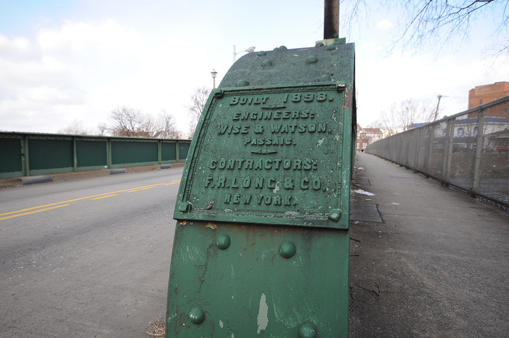
Macomb’s Dam Bridge

Alfred P. Boller was chosen as the head engineer of the construction of the new bridge. Boller had a solid reputation as a structural engineer with an eye for aesthetics, which was apparent in the design he selected for the new bridge.

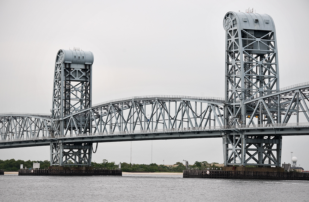
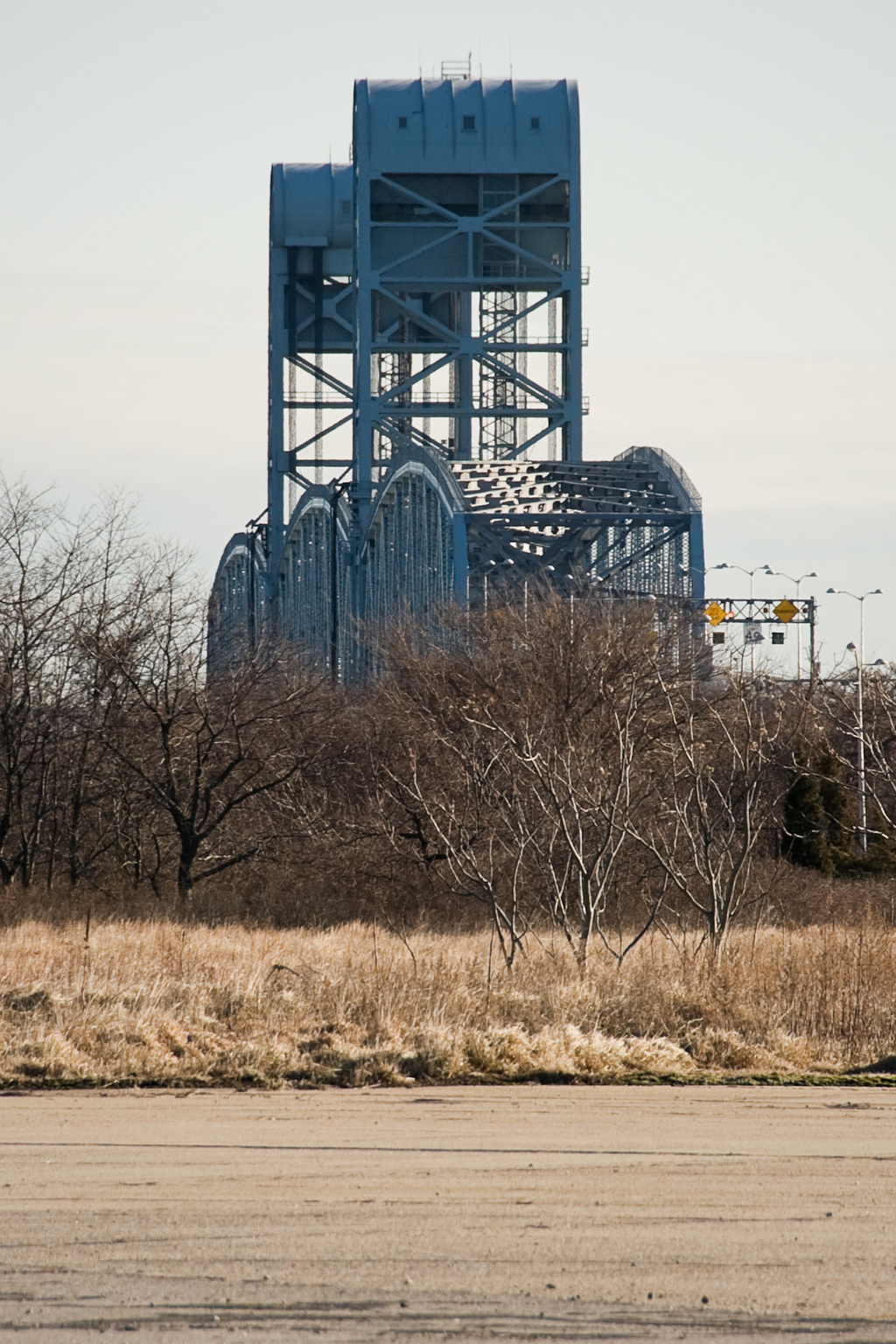
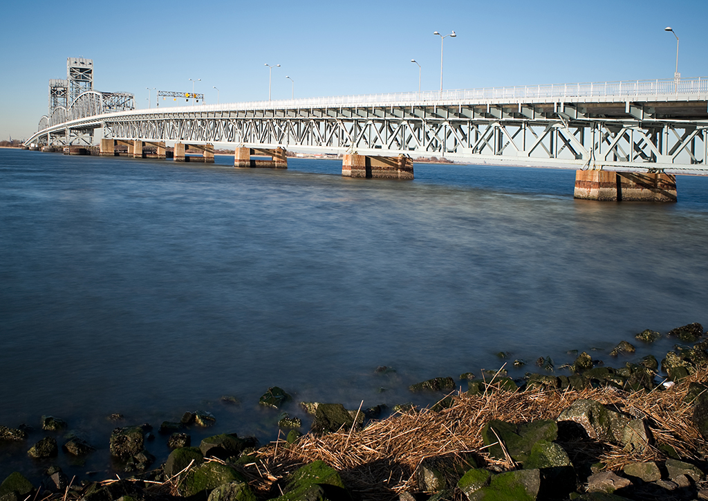
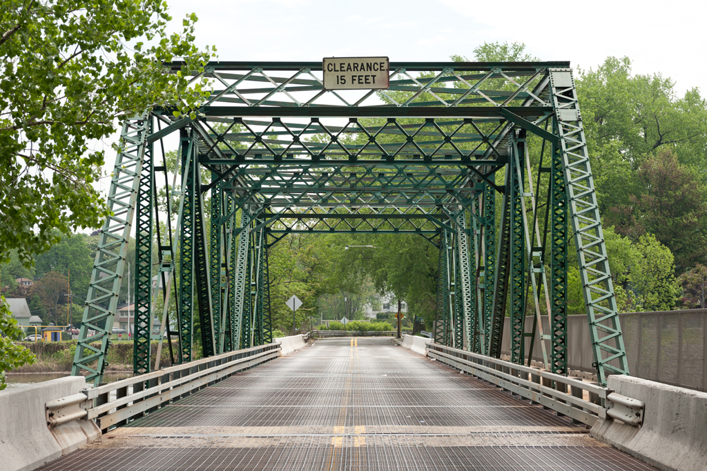
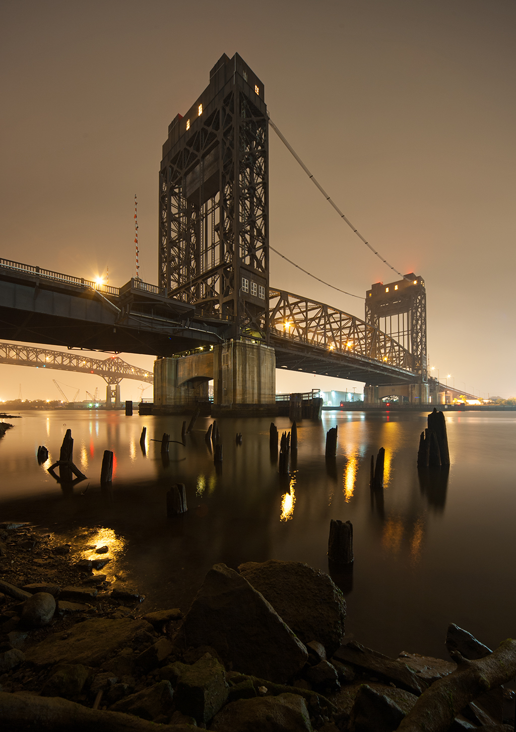
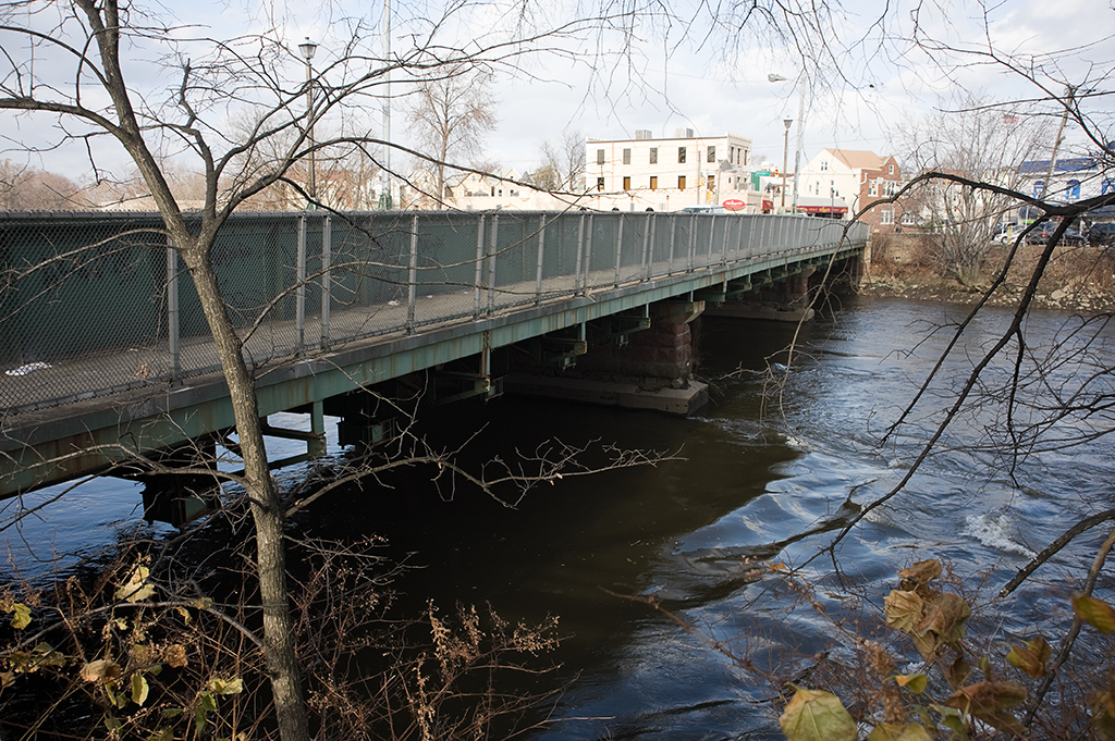
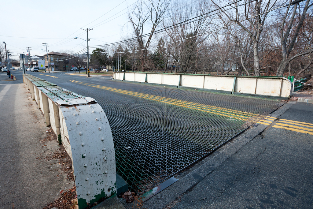
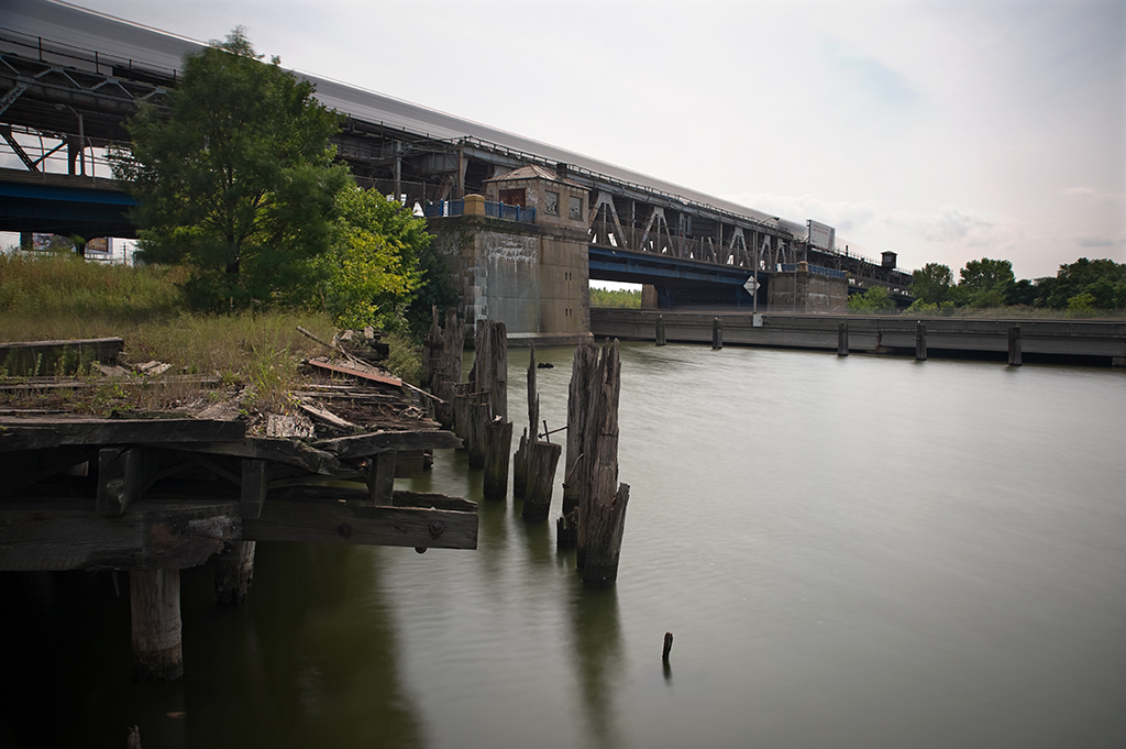
Macomb’s Dam Bridge is a swing bridge, with a span that rotates on a center pivot to make way for boat traffic on the river. The movable span is a 415-foot long Pratt through truss structure with a rectangular central tower adorned with decorative finials and top chords gracefully curving down to the deck with a concave profile. At the time of construction, the span was said to be the heaviest movable structure in the world. The piers that support the ends of the movable span when in the closed position are constructed of granite, with large archway openings on the bottom. On top of both ends of the piers are stone gate tender’s houses with red shingled pyramidal roofs.

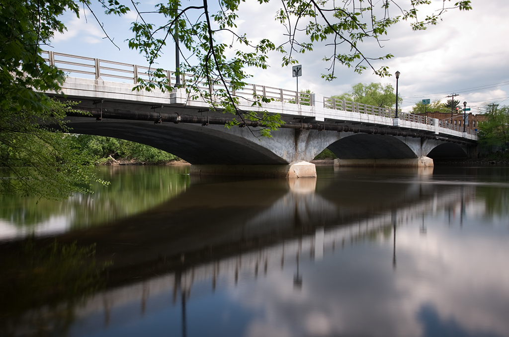
The approach on the Manhattan side is composed of a V-shaped intersection, with Macombs Place, formerly Macomb’s Dam Road, on the south, and West 155th Street, carried on a large viaduct on the west. The 155th Street Viaduct was built at the same time as the bridge, and was also designed by Boller. It is 1600 feet long and about 61 feet feet wide. It is a steel structure, composed of deck girder spans carried on two parallel rows of steel columns across the valley from the heights above Harlem.

Bridge plaque reading "Central Bridge"
Bridge plaque reading “Central Bridge”

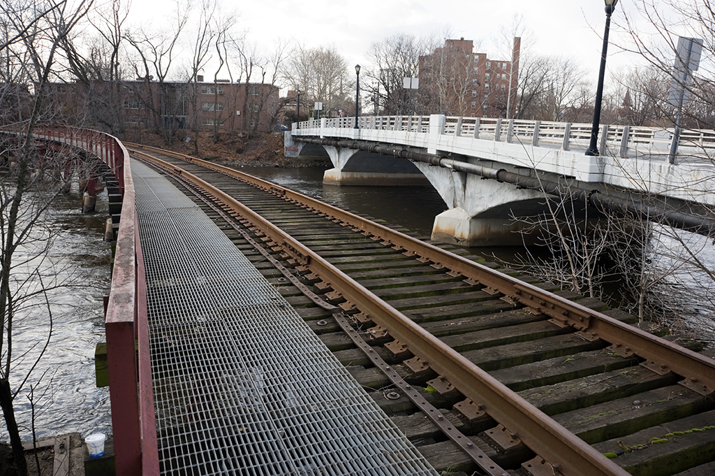
The approach on the Bronx side of the bridge is composed of two Warren deck truss spans on masonry piers, six steel girder spans installed between 1949 and 1951 with the construction of the Major Deegan Expressway, and most noticeably, a 221 foot camelback through truss carrying the roadway over the Metro-North tracks below.

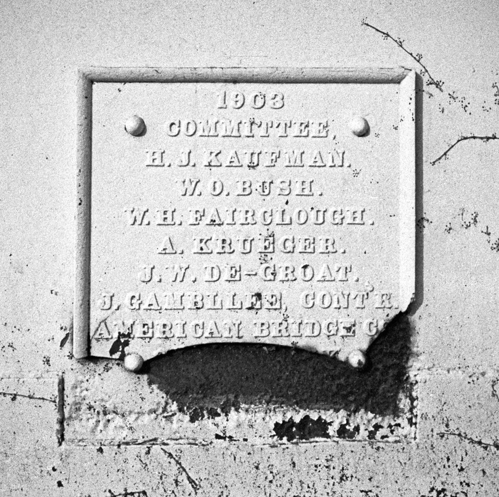
Construction of the bridge began in 1892, and the old bridge was moved up the river to a set of temporary piers at 156th Street to act as an alternative crossing while the new bridge was being built. The swing span and Bronx approaches for the bridge were built by the Passaic Rolling Mill Company of Paterson, NJ. The 155th Street Viaduct was built by the Union Bridge Company of Athens, PA. The ornamental iron railings and stairways on the bridge and viaduct were made by Hecla Iron Works of Brooklyn.

The bridge opened to traffic on May 1, 1895. An announcement published in the next day’s New York Times said simply, “The new Macomb’s Dam Bridge, which crosses the Harlem River at One Hundred and Fifty-fifth Street, was opened at 9 o’clock yesterday morning. There was no particular ceremony” (New Macomb’s Dam Bridge Opened).

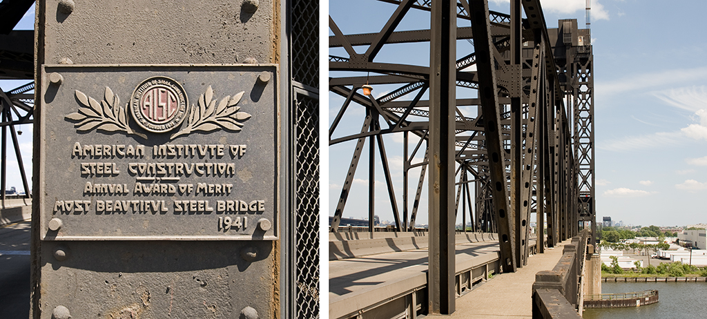
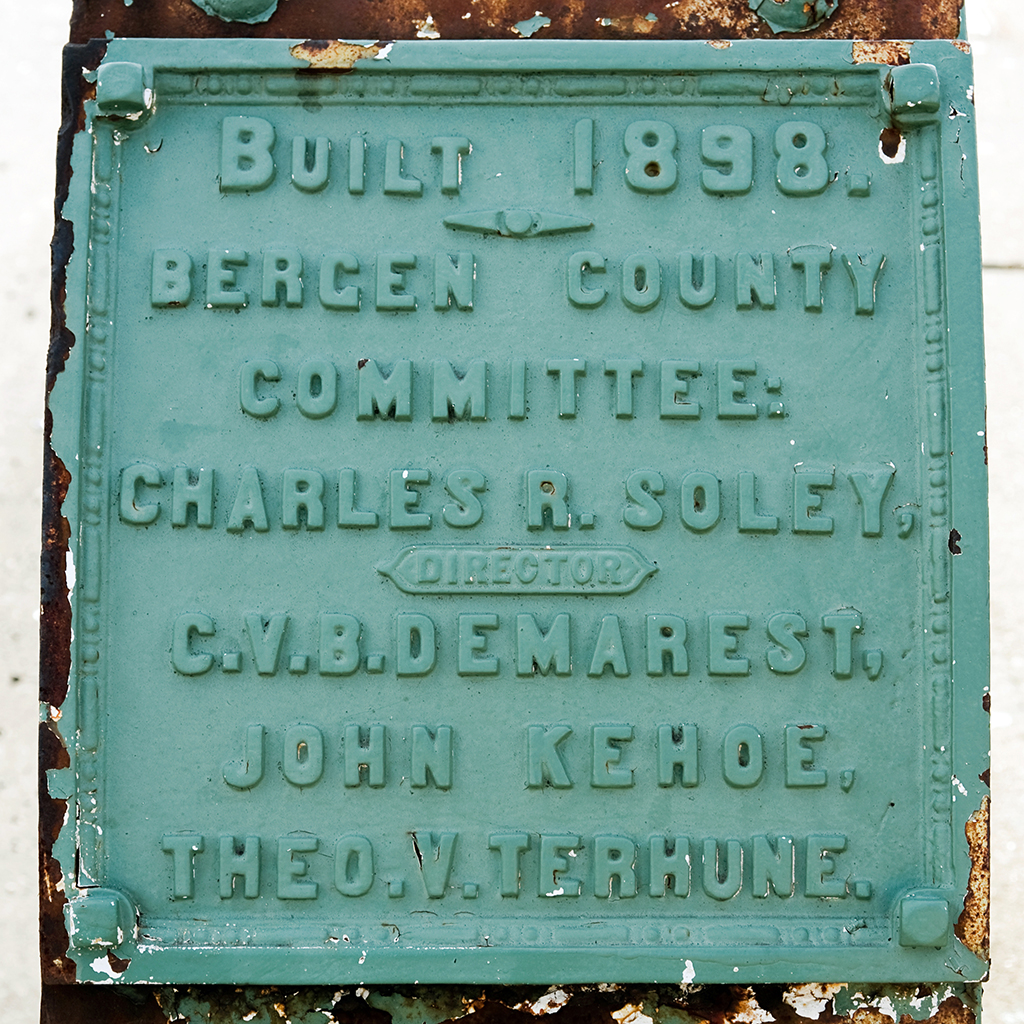
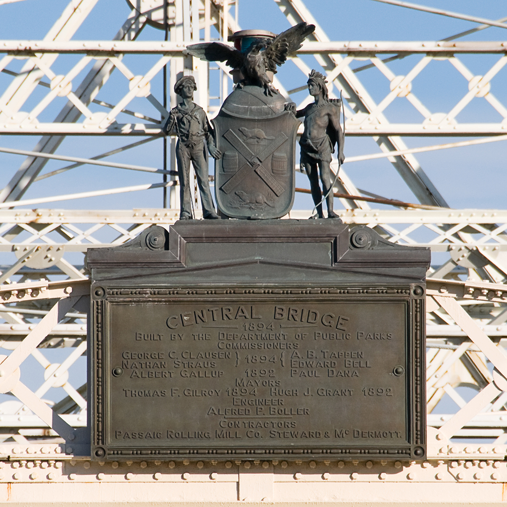
The official name for the new bridge was also Central Bridge, as indicated by the ornamental plaque that still exists on the western side of the swing span. That name, however, never fell into popular use, with almost all New Yorkers continuing to refer to it by its old name, Macomb’s Dam Bridge. Martin Gay, Bridge Commissioner for the city in the early 1900’s decried the Central Bridge name as being “meaningless” (1904, Harlem River Bridges). A resolution by the Board of Alderman officially renamed it as Macomb’s Dam Bridge on November 11, 1902.

Macomb's Dam Bridge from the Harlem River
Macomb’s Dam Bridge from the Harlem River

[ continue to references ]

Marine Parkway Bridge

Marine Parkway Bridge

Crosses: Rockaway Inlet in Jamaica Bay
Connects: Floyd Bennett Field, Brooklyn and the Rockaways, Queens, NY [satellite map]
Carries: 4 vehicular lanes, 1 pedestrian sidewalk
Design: vertical lift bridge
Date opened: July 3, 1937
Postcard view: “Marine Parkway Bridge, Brooklyn, N.Y.”

The Marine Parkway Bridge (also known as the Marine Parkway-Gil Hodges Memorial Bridge) is a vertical lift bridge which connects Flatbush Avenue at Floyd Bennett Field in Brooklyn with Jacob Riis Park and Fort Tilden in the Rockways in Queens.

Plans for a New Bridge: Robert Moses & The Marine Parkway Authority

Fiorello LaGuardia was narrowly elected Mayor of New York City in 1933; he would serve three terms from 1934 to 1945. LaGuardia was impressed by the parkways Robert Moses had built in Long Island (and by his ability to raise federal funds to finance them), and he immediately offered him a job in his administration. Moses had plans for parkways and parks in New York City ready to go, and he only agreed to take the job from LaGuardia if he would have control of the parks departments in all five boroughs, which had previously been independent of one another. Moses also wanted control of the parkways; LaGuardia agreed. Moses quickly took over the the Triborough Bridge Authority; that bridge’s construction had begun in 1929 but had stalled and remained incomplete. He also introduced a plan to finance construction of the Marine Parkway Bridge that called for the creation of the Marine Parkway Authority, of which, of course, Moses would be chairman and sole member. He raised money for these and other projects (which would charge tolls when they opened) by issuing bonds; when a project was complete, he would not sell off the bonds but would begin another toll-collecting project, continuing the cycle.

Opposition

Moses issued $6,000,000 in bonds in order to build the Marine Parkway Bridge, and it was expected that within 25 years, through toll collection the bridge would pay for the loan and allow the bridge to be self-sustaining. However, there was plenty of opposition to the bridge proposal. The surrounding communities had been served by ferries and many people did not want to see that change. There were others who felt that Jamaica Bay might one day become a major port and the building of a bridge would destroy that potential. So, more than $18 million was spent by the U.S. War Department to dredge Rockaway Inlet and the bridge was designed to be a lift span, to enable the channel to remain clear for ship traffic. There was also the issue of ice: it was feared that ice would pile up on the bridge piers and either block passage or cause the surrounding areas to flood, sweeping cottages along Rockaway Beach out to sea. The solution was to bring in a forest of 600-foot-tall Douglas fir trees from the west coast to be driven into the sand and act as fenders against the ice around the bridge’s piers.

Marine Parkway Bridge, seen from Floyd Bennett Field

The Barren Island Squatters

Another problem encountered before construction of the bridge could begin was a well-established colony of squatters living on what formerly was known as Barren Island. Barren Island was a roughly three mile long and one mile wide stretch in the southern Brooklyn section of Jamaica Bay. In the late 1800s, the land at either end of the island the island was home to several putrid-smelling industries including fish, fat, and offal rendering plants and another that rendered horse bones into glue, leading to the the body of water on the island’s western shore’s name: Dead Horse Bay. About 120 acres in the center of the island was owned by the city, intended to be used as a dumping ground. However, due to the city’s neglect, the land was taken over by a colony of squatters, who by 1877 numbered around 100. The squatters kept livestock such as goats and pigs, and even set up a liquor saloon on the island. The stench of the rendering plants grew worse and worse, and after years of complaints from Brooklyn residents, the plants were required to dump their refuse at sea. The Brooklyn Daily Eagle described the situation in 1899 as being “improved:”

Nowadays the ancient cheeses, the butchers’ offal, the long-deceased animals, the contents of refuse cans and barrels are not piled along the waterfront… On the contrary, the process is quick and thorough. Deodorizing substances are freely used in the materials that are disgorged from New York’s thousands of kitchens and butcher shops. The sufferings that are reported in various parts of Brooklyn and along the south shore probably result in larger measure than the people realize from the dumping which is still carried on at sea, the scows going out six or eight miles, instead of the required forty, and throwing overboard tons of swill that the incoming tide washes upon the shored of Coney Island, Rockaway and even Long Beach. This vile stuff festers in the sun, sours and breeds maggots and flies by millions. [1]

Despite many attempts over the years to remove the squatters, they stayed put. Barren Island was connected to the Brooklyn mainland with landfill during the construction of Floyd Bennett Field (New York City’s first municipal airport), which opened in 1931. By then the rendering plants were long gone, but the squatters still remained. In 1936, Robert Moses, as Park Commissioner, called for their eviction; at that time there were an estimated 90 squatters (and their livestock) still living on the former island. They were given until April 15, 1936 to vacate, and Alderman Joseph B. Whitty of Brooklyn was granted a promise by Mayor LaGuardia that the houses on the island would be treated as “condemned tenements” [2], so that the squatters would be provided with free moving service as they left the island. In August of the same year, five acres of marijuana plants were discovered on the island, upon which the goats the squatters had kept had been grazing. The squatters, when questioned, denied that there was any other intended use for the plants.

Engineering

Moses the planner had engineers ready to work on the Marine Parkway Bridge. The chief engineer on the project was Rensselaer Polytechnic Institute graduate Emil H. Praeger (who worked on numerous projects for the Parks system and went on to design the Tappan Zee Bridge). The firm of Madigan-Hyland were also involved as engineers. Robinson & Steinman were hired as consultants; Holton D. Robinson was the engineer of the Williamsburg Bridge and David Steinman designed the Henry Hudson Bridge as his thesis while at Columbia University. The title of Engineering Designer was filled by the esteemed Waddell & Hardesty, formed in 1927. Also both Rensselaer graduates, the firm of J.A.L. Waddell and Shortridge Hardesty was known for its movable bridge designs, especially vertical lift spans. The contractors awarded the bids for construction of the bridge were the Frederic Snare Corporation and the American Bridge Company.

Construction & Design

Construction began on June 1, 1936. A method differing from usual lift bridge construction was used, where instead of floating the lift span in at the very end, it was placed partway through, planned to coincide with a particularly high tide. Just after midnight on January 12, 1937, 38 workmen from the American Bridge Company began the operation; tugboats guided the central span along and at 7:45 a.m., while the tide was at its highest, it was placed into position. The partially built towers had a special trestle attached to their foundations from which the towers would be completed.

The bridge is designed of three main 540-foot spans, each allowing for a 500-foot clear channel. There are two 1,061-foot approaches; its total length is 4,022 feet, 6 inches. The 2,000-ton central span could be raised from 50 feet to a total clearance of 150 feet above the high water mark in two minutes. When it was completed it was the longest highway lift bridge in the world (it is still the longest of its type in North America), built of 12,000 tons of steel and 47,000 cubic yards of concrete. The bridge was painted olive green with silver trim. The roadway, instead of being solid, was built of steel plates, similar to subway gratings set in sidewalks throughout the city. It was the first roadway of this type to be used on a bridge on the East Coast. The open grates were also painted green.

One complaint about vertical lift bridges at the time was that their appearance could be ugly; often they were employed by railroads and were decidedly utilitarian in design. In response to this, the towers of the Marine Parkway Bridge were tapered and a pattern designed to hint at the great wheels that lifted the bridge rather than hiding them [3]. Construction was finished less than a year after it began, and the bridge was scheduled to open in July, in time for motorists to enjoy the summer in the new Jacob Riis Park.

Marine Parkway Bridge from Rockaway

Opening Ceremony

The bridge officially opened on July 3, 1937. The ceremony was headed by Mayor LaGuardia who was joined by Park Commissioner Robert Moses and various other city officials. 500 cars full of invited guests waited on the Brooklyn side of the bridge, on the approach built on Barren Island. Guns were fired from Fort Tilden, fireboats sprayed water into the air, and nine Martin planes flew in formation overhead. The center span was lowered for traffic and at 10:30 a.m. a parade of cars began to cross the bridge to Jacob Riis Park, where Moses gave a speech detailing the planning that had led up to the building of the bridge. It was given recognition in the engineering world as well: The National Steel Bridge Alliance awarded it first place in the movable bridge category in 1937.

Renaming & Rehabilitation

The bridge was renamed in 1978 in honor of Gil Hodges, a former Brooklyn Dodgers first baseman, though the name has not taken into common usage [4]. The Marine Parkway Authority was absorbed into the larger Triborough Bridge Authority in 1940 (becoming he Triborough Bridge and Tunnel Authority in 1946). Traffic and toll collection on the Marine Parkway Bridge did not turn out to be enough to pay for its own expenses, but other bridges and tunnels run by the TBTA were profitable enough to carry those that were less so. The TBTA is now under the jurisdiction of the MTA, who began a major rehabilitation project on the bridge in 1998. The steel deck was replaced with concrete and steel, a “Jersey” barrier was added to separate traffic, electrical systems and traffic control were updated, and new signs were put in place. The $120 million project was finished in 2004; the bridge still opens more than 100 times a year.

[ continue to references ]

Midtown Bridge

Midtown Bridge from Oscar E. Olsen Park in Bogota, 2015

Crosses: Hackensack River
Connects: Hackensack and Bogota, NJ [satellite map]
Carries: 2 vehicular lanes, 1 sidewalk
Design: (former) swing bridge, fixed into place in 1984
Date opened: 1900

The Midtown Bridge, also known as the Salem Street Bridge and William C. Ryan Memorial Bridge, is a fixed through truss bridge that was formerly a swing bridge. It spans the Hackensack River, connecting Hackensack and Bogota in Bergen County, New Jersey.

Midtown Bridge-03
Passaic Rolling Mill Co. founder’s mark on steel beam

The bridge was originally built in 1900 by F.R. Long and Company as a trolley bridge for the Bergen County Traction Company. Steel for the bridge was provided by the Passaic Rolling Mill Company of Paterson, NJ. The bridge’s original design was a through Pratt truss swing span on a stone center pier and it carried two sets of tracks. The Bergen County Traction Company had been formed in 1894, and opened in 1896, connecting ferry passengers traveling from Manhattan to Edgewater to trolley lines to Fort Lee, Leonia, Englewood, Teaneck, Bogota, and Hackensack. The lines were consolidated in 1900 into the New Jersey and Hudson River Railway Company and later sold to the Public Service Corporation of New Jersey in 1910. The Bergen Division of the Public Service Railway continued to carry trolleys over the Hackensack (a 1937 image can be seen in Figure 139 (page 189) of Streetcars of New Jersey: Metropolitan Northeast [1]).

However, with the rise of the automobile, transportation was changing, and trolley routes began to be replaced by buses. By 1938 all trolleys had been discontinued in Bergen County; the bridge’s tracks were replaced with a steel deck and in 1940 the Midtown Bridge began carrying vehicular traffic. It continued to operate as a swing bridge until a rehabilitation project in 1984, when it was fixed in place and its machinery was removed. In 1980, the bridge was given the additional name of “Ryan Memorial Bridge,” named after Bogota resident and U.S. Marine Corps Lieutenant William C. Ryan, who was killed in North Vietnam in 1969.

Steel deck, 2010
Steel deck, 2010
Ryan Memorial Bridge plaque

The Midtown Bridge has only recently been notable for being in need of repair. It was shut down for several weeks in 1998 by the Department of Public Works so that emergency repairs could be made to its steel joints. The issue was described by county engineer Robert Mulder as “an ongoing problem that needs to be permanently fixed” [2]; however, that fix has been continually delayed. A project to rehabilitate the Court Street Bridge, another former swing bridge in Hackensack downriver from the Midtown Bridge, meant that it was closed from 2010-2012, with much of the Court Street Bridge’s traffic diverted to the Midtown Bridge during that time. On October 17, 2013 the Midtown Bridge was shut down for emergency repairs again; Bogota’s Council President and Office of Emergency Management coordinator Tito Jackson had noticed a large separation in the bridge’s metal decking at its joints [3]. The current plan is to replace the aging span with a bridge with a concrete deck. Bergen County is home to a number of bridges in need of major repair or replacement, so there is no timetable for the project as of yet.

[ continue to references ]

Mill Creek Footbridge

Replacement Mill Creek Footbridge, 2013

Crosses: Mill Creek
Connects: Jersey Avenue and Liberty State Park, Jersey City [satellite map]
Carries: Pedestrian/cyclist sidewalk
Design: Arch bridge
Date opened: May 23, 2013

The Mill Creek Footbridge connects Jersey Avenue in downtown Jersey City, NJ with Philip Street in Liberty State Park. The current bridge replaced an older structure that was destroyed on October 29, 2012, during Hurricane Sandy. Mill Creek feeds into the Morris Canal Basin (now used as a marina) and then the Hudson River.

Original Bridge

Little information is available about the original bridge. Taking into account that maps may be inaccurate, it appears that a Jersey Avenue road bridge crossing Mill Creek was built sometime between 1874 and 1889. A railroad bridge running parallel to it was constructed by 1904. The railroad trestle carried both the Lehigh Valley Railroad and the Central Railroad of New Jersey. Both lines terminated before crossing the Morris Canal to the north (the canal was located just south of Grand Street). The road portion was demolished at some point between 1928 and 1955. Following the decline of the railroads in Jersey City, the trestle was abandoned and the bridge was converted into a footbridge sometime thereafter. The Jersey Journal notes that city officials do not know exactly when the bridge became a footbridge, and Sam Pesin (president of the group Friends of Liberty State Park) thinks it was there when the park opened in 1976 [1].

Original Mill Creek Bridge, 2010

The Jersey Avenue Extension

Various proposals have been made over the last twenty years or so to extend Jersey Avenue over Mill Creek, connecting Downtown with Liberty State Park, as well as providing additional access to the New Jersey Turnpike. The city applied for an $18.4 million federal grant in 2011 to fund the extension. The proposal argues that the extension would ease traffic in the nearby Bergen-Lafayette neighborhood. However, it has also sparked debate among residents over how much local streets would be impacted by cars exiting the Turnpike to avoid traffic at the Holland Tunnel; cars cutting through local Downtown streets have long been an issue. The proposal acknowledges this and tries to defend its position:

The city is also mindful that this new direct connection could be perceived as a short cut for out-of-town commuters by using the 1.2-mile corridor between New Jersey Turnpike Exit 14B and Grand Street to access Jersey City’s central business district or the Holland Tunnel. This corridor traverses Liberty State Park and residential development areas. To achieve the overall goal of improved connectivity and access without increasing traffic speeds and/or inducing additional traffic through the environmentally sensitive park areas or future residential neighborhoods, a series of modern roundabouts are proposed in the park segments and a more pedestrian friendly “complete street” is proposed in the northern segment of dense urban development. [2]

The city was not given the grant and the footbridge was destroyed the following October during Sandy. Initially, it was speculated that the city would not replace the footbridge at all, in hopes that it would be able to begin construction on the Jersey Avenue Extension, which would include a pedestrian pathway. However, it was decided that the footbridge would be replaced (a widely-held suspicion is that it was given priority because 2013 is an election year). In March of 2013, Jersey City was awarded $500,000 by the federal government to do a feasibility study for a road extension; that proposed bridge would run parallel to the new footbridge, which was set to open by Memorial Day weekend.

Hurricane Sandy damage, November 2012

The new Mill Creek Footbridge was delivered on May 1 and opened on May 23rd. It is a prefabricated arch bridge that is painted white; it has a somewhat higher clearance over the creek than its predecessor. It was scheduled to cost about $750,000 and wound up costing about $800,000. Jersey City has applied to the Federal Emergency Management Administration, which could reimburse the city for most of the cost of the bridge. It is officially called the Ethel Pesin Liberty Bridge, in honor of a founding trustee of Friends of Liberty State Park (and wife of Sam Pesin). She died in February, 2013, at age 98.

Original walkway, 2010 (left); Replacement walkway, 2013 (right)

[ continue to references ]

Monroe Street Bridge

Monroe Street Bridge

Crosses: Passaic River
Location: Monroe Street connecting Passaic and Garfield, NJ [satellite map]
Carries: 2 vehicular lanes, 1 pedestrian sidewalk
Design: arch bridge
Date opened: June 13, 1908
Postcard view: “Monroe Street Bridge, Passaic, N.J.”

The Monroe Street Bridge is a reinforced concrete arch bridge over the Passaic River in New Jersey, connecting the towns of Passaic and Garfield.

Gilbert D. Bogart & East Passaic

In early 1873, Gilbert D. Bogart set out to develop a suburb to the town of Passaic, which he called East Passaic. He and his associates formed the East Passaic Land Company and bought property along the Passaic River from Monroe Street to Van Winkle Avenue. His company was responsible for the first development in the area. In 1875, a bridge across the Passaic was built at Monroe Street by Joseph Scott, and seven houses were also constructed. However, the financial panic of 1873 brought Bogart’s project to a grinding halt. Lots on the land acquired by the East Passaic Land Company could not be sold even at greatly reduced prices. The company suffered heavy losses and years passed without any sign of recovery.

On December 8, 1878, Scott’s Monroe Street Bridge was washed away when the Passaic River overflowed its banks. In 1881, the Bergen County Short Cut (a branch of the Erie Railroad) was laid along Monroe street, and a rail bridge was built to Passaic (next to where the washed-out bridge had been); a station was created and named after President Garfield.

Rail bridge next to the Monroe Street Bridge

Things still were not improving for Bogart’s company, and in 1882 it sold all its land under foreclosure to the Garfield Land Association. The name “East Passaic” had become associated with failure and the town adopted the name of Garfield instead. The land was sold as individual lots by the Garfield Land Association with the remainder going to the newly formed Monroe Street Bridge Land Company, which built a replacement bridge shortly after.

The Current Bridge

The bridge currently crossing Monroe Street was built in 1908 by the C.W. Dean Company of New York. The plans for the bridge had been put together by F.R. Long Company Engineers and Contractors in August of 1907. It is a three-span, 306-foot long deck arch bridge on a concrete and stone substructure. The bridge is made up of three equal elliptical arch spans. It originally featured a decorative railing with vase-shaped balusters. The bridge was important to the industrial and commercial development of both Passaic and Garfield, and is the only existing pre-World War II multi-span concrete arch bridge remaining in the United States.

The Monroe Street Bridge opened on June 13, 1908. A parade was held and Mayor John Karl of Garfield and Mayor Frederick R. Low of Passaic met to officially open the bridge to the public. A celebration was held in a nearby park afterward.

Alterations

The Monroe Street Bridge has been repaired extensively over the years. In 1947 guide rail was added to the curbs, and new concrete curbs followed in 1948. Many repairs to the substructure were made using gunite (a dry form of shotcrete) in 1949. Large parts of the balustrades were missing or badly damaged, and they were replaced by a more utilitarian railing sometime after Bergen County did a survey the bridge in the early 1980s. New Jersey’s 2002 survey of the bridge deemed that it had lost much of its “visual integrity” due to the nature of the gunite repairs [1].

[ continue to references ]

Passaic River Bridge (1&9)

Passaic River Bridge with Pulaski Skyway in background

Crosses: Passaic River
Connects: South Kearny and Newark, NJ [satellite map]
Carries: 4 vehicular lanes, 2 sidewalks
Design: vertical lift
Date opened: January 26, 1941

Traveling east along the 1&9 Truck Route from Newark to Jersey City, you may notice a small steel plaque on the Passaic River crossing proclaiming that span to be 1941’s Most Beautiful Steel Bridge. That designation, given by the American Institute of Steel Construction, was awarded the year that bridge opened to traffic.

The bridge replaced a low level swing span that had been in place since 1921. That bridge, with a 10 foot clearance over the river, required an average of 30 openings a day to accommodate marine traffic, causing significant automobile traffic delays. Problems were exacerbated by the opening of the Holland Tunnel in 1927 as the final link between the interstate Lincoln Highway and New York City. Though the opening of the Pulaski Skyway, located just a short distance north of this route, was intended to alleviate these problems, the Skyway was effectively obsolete as soon as it was opened to traffic. The diversion of all truck traffic from the Skyway in 1933 further complicated problems along the route. Construction of a new span commenced in 1938, at a projected cost of two million dollars.

Design

The vertical lift design of the new bridge required the construction of two large steel towers on each side of the navigation channel, connected by a movable deck, which has a span of 332.5 feet. In the closed position, the new bridge provided 40 feet of clearance over the Passaic, reducing the number of daily bridge openings to an estimated 5 per day. Tower drive motors, a fairly new innovation at the time, were able to lift the deck 95 feet above its closed position, allowing for a maximum of 135 feet clearance, a minimum height specified by the War Department for marine crossings. The chief engineer was Morris Goodkind, with the firm of Howard, Needles, Tammen and Bergendoff as consulting engineers. The substructure was fabricated by Senior and Palmer and the superstructure by the American Bridge Company.

Plaque and bridge walkway

Construction

The Passaic River Bridge took three years to complete under the supervision of lead engineer Morris Goodkind and the New Jersey State Highway Commission, with the final cost just barely exceeding the projected estimate by just under $56,000. The bridge was constructed as close to the south side of the old span as logistically possible in order to ease the transfer of the traffic alignment from the old bridge to the new. During the final phase of construction, with everything in place except for the moveable deck, river traffic was halted for 72 hours while the deck could be installed.

In what must have been a very carefully choreographed procedure, the deck was floated into the work location on a barge at high tide and aligned with the rest of the structure. As the tide receded, the deck gradually sank into position on the bridge piers. After the 64 lifting ropes attached to the lift’s counterweights were connected to the deck, the bridge was essentially complete, save for some fine tuning needed to ensure proper bridge operation. It was opened to traffic at 11 PM on Sunday, January 14th, 1941.

[ continue to references ]

Passaic Street Bridge

Passaic Street Bridge

Crosses: Passaic River
Connects: Wall Street, Passaic and Passaic Street, Garfield, NJ [satellite map]
Carries: 2 vehicular lanes, 2 pedestrian sidewalks
Design: girder bridge
Date opened: 1898

The Passaic Street Bridge is the earliest known example of a multi-span through-girder bridge in Bergen County, New Jersey. It connects the towns of Passaic and Garfield and is the third bridge at that location.

The Iron Bridge

The first bridge to cross the Passaic River at Garfield was known as the Iron Bridge; it opened in 1868. On September 11, 1871, one of the bridge’s three spans collapsed while carrying a team of horses and a driver. All fell into the Passaic, and while the horses escaped without injury, their driver was killed. A decision was made to completely rebuild rather than repair, and a new Iron Bridge opened in 1872.

plaque
plaque

That bridge was replaced in 1898 with the current structure, again made of iron but also reinforced with cement. The engineers on the project were the Wise & Watson Company of Passaic. The builders were the F.R. Long Company. The bridge is 233 feet long and, like its predecessors, is composed of three spans resting on ashlar masonry abutments.

The Flood of 1903

The summer of 1903 brought above average rainfall, and a tropical storm hit the east coast in early October. For nearly two weeks the Passaic River overflowed its banks in what became known as the Flood of 1903 (still the largest on record for the area). Almost all the bridges downriver of the Great Falls in Paterson were washed away, but the Passaic Street Bridge managed to survive the torrents.

Alterations

The Passaic Street Bridge has undergone a few rounds of alterations, none of which are considered to impact its historic status [1]. Welded plates were added to the deck girders and concrete caps to the masonry below the bridge. In 1989 the bridge was rehabilitated, with the deck and stringers replaced and the floor beams mended.

011passaicst03
Passaic Street Bridge from the Passaic side of the river

[ continue to references ]

Passaic Street Bridge, Lodi

Passaic Street Bridge

Crosses: Saddle River
Location: Carries Passaic Street over the Saddle River in Lodi, NJ [satellite map]
Carries: 2 vehicular lanes, 2 pedestrian sidewalks
Design: Through-girder bridge
Date opened: 1903

The Passaic Street Bridge carries Passaic Street (which becomes Passaic Avenue and feeds into Main Street) across the Saddle River in Lodi, New Jersey. It was built by the American Bridge Company in 1903. It is a through-girder bridge that rests on stone abutments. In 1939 (and again in 1971), the girders underwent repairs and welded plates were added to strengthen them. Also in 1971, much of the original concrete encasement on the floorbeams was removed and a metal deck was installed. Some of the original metal railing remains on the span, and one partially-broken plaque gives information on the bridge’s construction. New Jersey’s 2002 Bridge Survey notes that the bridge is one of more than 20 of its type in the state, and due to the construction on it over the years, “the altered span has lost its visual integrity and it is not distinguished.” [1]

plaque
Bridge plaque

Though the bridge may not be unique in its construction, it is of a type that is frequently replaced with more modern spans, and over its 110-plus years in existence it has been witness to much change in Lodi.

Industry on the Saddle River

The town of Lodi has existed in some form since Revolutionary times, and the township of Lodi was organized in 1825, taking  its name from a town in Italy. The Saddle River was important to the growth of the town into a manufacturing center. By the late 1800’s, the river provided the power to two grist- and saw-mills, a bleaching and dyeing factory called United Piece Dye Works, and the Lodi Chemical Works. [2]

The borough of Lodi was incorporated in 1894 out of Lodi Township and Saddle River Township, during New Jersey’s period of “Borough Fever” of the late nineteenth century. Starting in 1894, New Jersey allowed new boroughs to be formed by petition, rather than as a special act of the state legislature. Bergen County took particular advantage of this–56 out of 70 total municipalities in the county are now boroughs.

United Piece Dye Works

The late 1890’s saw an influx of immigrants, mainly from Italy, coming to Lodi to work at the United Piece Dye Works. The factory was  just upstream from the current location of the Passaic Street Bridge on the Saddle River. The dye made there became a part of the landscape. Anthony Taormina, who was born in Lodi in 1954 and went on to become the director of its library from 1986 until his retirement in 2011, described the Dye Works’ effect on the the river:

“I remember my mother telling me about walking over the Passaic Street bridge on her way to school, looking at the different chemical colors coming down the Saddle River. One day it would be green, one day it would be blue, depending on what color they were dying that day.” [3]

Chemical Manufacturing

Plaque in Lodi Memorial Park commemorating the victims of the Napp Technologies explosion

During the Great Depression, much of the textile business that had been in and around Passaic, NJ  moved south in order to cut labor costs. United Dye Works closed in the 1950’s and soon chemical manufacturers moved into the town.

An explosion tore the roof off a building at the B.L. Lemke Company in April of 1969, killing one person and wounding six. In August of 1973, an explosion at the Mallinckrodt Chemical Company killed seven employees. After that incident, the town cracked down somewhat on the industry: it prohibited new chemical companies from moving in and prevented the existing ones from expanding further.

B.L. Lemke later became Napp-Lemke Chemicals, and later still Napp Technologies. In April of 1995 another explosion rocked the complex, killing five and injuring seven. Approximately 400 residents of Lodi were evacuated. The Saddle River turned a fluorescent green color from the chemically contaminated water runoff generated by firefighting efforts at the plant.

Lodi’s problems with chemicals weren’t limited to explosions. The town once got its water from natural wells, run by the Lodi Water Works. In 1983, they were shut down after it was discovered that they had been contaminated by thorium, a radioactive chemical made in Lodi by another chemical company. Water has been piped in from elsewhere ever since.

Legislation introduced after the Napp Technologies explosion prevented the company from reopening in Lodi. The area it once occupied now is parkland and a shopping area.

Flooding

The Saddle River has flooded many times over the years. In March 1902 the water rose 14 inches above the previous bridge. Though no information has been found to support this, it can be speculated that the bridge was replaced in 1903 because of damage done during the 1902 flood (this was the case with many bridges over the nearby Passaic River). An even larger flood occurred in October of 1913: the Saddle River reached a height of six-and-a-half feet above the bridge [4]. Floods continue today and local officials have attempted to pass legislation which would allow for dredging of the river, but the estimated cost of $100 million has held the project back [5].

replacement metal deck
Replacement metal deck

[ continue to references ]

Roosevelt Avenue Bridge

Roosevelt Avenue Bridge

Crosses: Flushing River
Connects: Corona and Flushing, Queens, NY [satellite map]
Carries: 4 vehicular lanes, 2 sidewalks, IRT 7 subway
Design: double-leaf bascule
Date opened: May 14, 1927

The Roosevelt Avenue Bridge is a double-deck, double-leaf bascule movable bridge over the Flushing River in northeastern Queens. It carries four lanes of Roosevelt Avenue and two sidewalks on its lower deck, and three tracks of the IRT Flushing / 7 train line of the New York City Subway on its top.

Planning

Surveying for the bridge began in 1913 as part of an extension of the Interborough Rapid Transit Company’s Woodside and Corona line. The original plan had the line mapped out between 42nd Street in Manhattan and Prime Street in Corona, with the extension reaching out to the village of Flushing, with a possible further extension to Little Neck at the city line. The line reached Corona in 1917, but United States involvement in World War I prevented further construction. Financial problems after the war delayed progress still until 1921, when city engineers began negotiations with the US War Department concerning what type of structure the city could build to cross the Flushing River. The War Department, which had jurisdiction over all navigable waterways and their crossings in the country at that time, denied a request by the city to be allowed to build a simple fixed bridge across the river on account of it being an obstruction to river traffic. A tunnel was briefly considered, but was decided against when cost estimates for it reached $2,500,000, more than the city was willing to pay. The War Department suggested the city build a bascule bridge, and officials relented.

Construction

Groundbreaking for the bridge was held on April 21, 1923 in a ceremony attended by Mayor John Hylan and Maurice E. Connolly, Borough President of Queens. Construction began soon after, though many delays occurred due to a recurring problem with the foundations of the bridge settling in the deep mud on the banks of the river. On May 14, 1927, the bridge was opened to pedestrians and a bus line was established between downtown Flushing and Willet’s Point Boulevard station, the temporary terminal of the line while the foundation issues were being resolved. Train service would not begin across the bridge until January 21, 1928, with a special train for city officials making the inaugural run from Time Square to the new station in Flushing. The extension to Little Neck has yet to be built.

view from the walkway
Roadway and sign

The final cost of the bridge was $2,640,000, more than the estimated cost of a tunnel under the river, even when adjusted for inflation. Despite the additional cost the city was required to pay for a movable bridge, the need to keep the river open to navigation did not last long. When construction of Flushing Meadows Park was under way in 1939, park engineers realized a dam was needed to keep the tides of the East River from inundating the low-lying fields. The Long Island Railroad, which runs just a few hundred feet upriver from Roosevelt Avenue, agreed to replace the swing bridge they owned over the river with a combined embankment and tidal gate on top of which they would continue to operate their trains. With no docking facilities in place between the two structures, navigation of the Flushing River effectively ended at the Roosevelt Avenue bridge. In 1961, construction of the northern extension of the Van Wyck Expressway began, and the route of the highway was driven directly through the navigation channel of the bridge, supported over the river by concrete piers. The operating mechanisms and bridge tender’s controls were finally removed at that point, and the bridge has not opened since.

Design

The Roosevelt Avenue bridge was the largest trunnion bascule bridge in the world when it was completed. It was designed by Edward A. Byrne and Robert E. Hawley of the NYC Department of Plants and Structures, and built by the Arthur McMullen Company of New York. The channel of the river at the point of the bridge is only 70 feet wide, but because of the skew of the route over the river, the clearance between the bridge piers is 162 feet. Together, the lift leaves are 153 feet long, and each weighs approximately 4 million pounds, supported by a truss structure 25 feet 6 inches deep. The piers that support the leaves are of poured concrete construction, with granite blocks covering the facings exposed to the water. Each pier measures 92 feet by 118 feet, and contains a large hollow space inside to accommodate the movement of the bridge’s counterweights.

Future

In January, 2010, the NYC Department of Transportation announced plans to rehabilitate the bridge starting in 2012. Years of neglect have resulted in a need to replace the road deck, repaint and repair rust on the steel truss and approach structures, and repair deteriorating concrete. The city also plans widen the sidewalks from 8 to 10 feet and establish bike lanes within them. The project is expected to be finished in 2015.

Update (04/29/2015): Rehabilitation has been delayed and is now expected to begin in mid-2015 with an end date to be determined.

[ continue to references ]

South Front Street Bridge

South Front Street Bridge in open position

Crosses: Elizabeth River
Location: Carries South Front Street over the Elizabeth River near its outlet into the Arthur Kill, Elizabeth, NJ [satellite map]
Carries: 1 vehicular lane, 1 pedestrian sidewalk
Design: Strauss heel trunnion bascule bridge
Date opened: 1922

The South Front Street Bridge is located just before the Elizabeth River opens up into the Arthur Kill, along the waterfront in Elizabeth, NJ.

Plans for a movable bridge at South Front Street were approved on July 3, 1916 by the Secretary of War. A riparian grant (a deed granted for normally state-owned tidelands) was obtained for $260 from the state of New Jersey in 1917, officially allowing the bridge to be constructed by the City of Elizabeth. The American Bridge Company built the bridge, beginning in 1920; it opened to traffic in 1922.

Design

The South Front Street Bridge is a Strauss trunnion bascule bridge; it was designed by the Strauss Bascule Bridge Company, headed by Joseph Strauss in Chicago. Strauss patented the Strauss bascule design of the trunnion type, which open on a fixed axle. The South Front Street Bridge is a heel trunnion, which is a variation on the design, and is the only remaining road-carrying bridge of its type in New Jersey (though there are still several heel trunnion railroad bridges in the state). The heel truss has the advantage of taking up less space than traditional bascule designs, thus requiring less construction material.

The bridge is skewed, so its trusses are of different lengths: 131’ 8” on the west side and 116’5” on the east. The bridge’s substructure and massive counterweight are made of concrete, which has undergone repairs several times. A small brick bridge house is located adjacent to the bridge; inside are the controls. The machinery which operates the bridge is on the bridge above the road; it consists of original gears and electric motors which were added in 1940.

The bridge was originally built with a wooden roadway, but it was replaced with a steel deck in 1956. The pedestrian walkway is still constructed of wood, though not the original wood deck. The bridge underwent significant repairs in 1976.

bridge deck
View from the bridge deck; the Chemical Control site is to the left.

The Elizabeth River’s Decline

The Elizabeth River was once home to six movable bridges, to accommodate its heavy use by ocean-going vessels. However, shipping on the river came to an end soon after the the 1951 opening of the New Jersey Turnpike. The U.S. Corps of Engineers deemed that three of the movable bridges would become fixed later in the 1950s. Another of the six (the Baltic Street Bridge) had been left isolated by the Turnpike construction, and it was sold for scrap in 1954. The South First Street Bridge, built in 1908, suffered a fire in the bridge tender’s house in 1984. With its control center gone, it permanently remained closed. The bridge was replaced completely in 2010. This leaves the South Front Street bridge as the only remaining operational drawbridge in all of Union County.

Only a few hundred feet of the Elizabeth River are still navigable, so the waterway only sees vessels designed for recreation, not industry. Still, a 2003 publication about Elizabeth estimated that the bridge was opened an average of 2,000 times a year [1].

Contamination Next Door

The bridge sits adjacent to the former site of the Chemical Control Corporation, a notorious part of New Jersey’s history with chemical dumping. The property, bordering on the southeastern end of the bridge, was originally marshland, but was filled in when Elizabeth developed much of its land for industrial use during the latter half of the 19th century. The Chemical Control Corporation was in operation from 1970 to 1978 as a disposal facility for hazardous waste. The company, which began as a legitimate business, became more notable for its practice of disposing of waste illegally, and was cited repeatedly until the state forced it to close in March of 1979.

concrete counterweight

The New Jersey Department of Environmental Protection began cleanup at the site shortly after; about 400,000 gallons of bulk solids and liquids, infectious and radioactive waste, and explosive liquids were removed. In May, upon hearing that the cleanup had uncovered nitroglycerin and other potential explosives, Elizabeth’s mayor Thomas G. Dunn declared a state of emergency in the area a half mile around the site, restricting pedestrian and vehicular traffic. The cleanup and restrictions were fortunate, because on April 21, 1980 there was an explosion at Chemical Control which led to a fire of spectacular proportions: drums of waste were launched into the air and exploded over the Arthur Kill; it took 10 hours to get the blaze under control but firefighters spent weeks at the site. NJDEP continued its cleanup and investigations after the fire; unfortunately, many of the records of which companies were connected to which hazardous materials were stored on-site and therefore lost.

In October 1981, it was proposed that the Chemical Control site be included on the National Priorities List of Superfund sites; its inclusion was finalized in September 1983. Cleanup continued, and a 1985-6 study found that contaminants including PCBs, naphalene, and benzene were still present in the soil, groundwater, and surface water. A slurry wall was later constructed around the site and anchored into a layer of clay under it; this helped stop groundwater contamination. A 2003 study of the site found that in general the contaminants which were contained during the cleanup remain contained, though it was noted that small area around the site may still be somewhat contaminated (one of three sampling stations still showed high levels of vinyl chloride and 2-butanone [2]).

plaque
plaque

The Bridge’s Future

In 2008, it was announced that the New Jersey Department of Transportation would supply $330,000 to repair the bridge. Work was done to reinforce the deck. The city was granted a further $1,000,000 in 2010 for more rehabilitation work. However, due to ongoing structural concerns, the bridge has been left in the open position since March 4, 2011; traffic is rerouted to the new South First Street Bridge. A study is underway to determine whether the bridge can be rehabilitated or not. The bridge remains eligible for the State and National Registers of Historic Places.

[ continue to references ]