Roosevelt Avenue Bridge

Roosevelt Avenue Bridge

Crosses: Flushing River
Connects: Corona and Flushing, Queens, NY [satellite map]
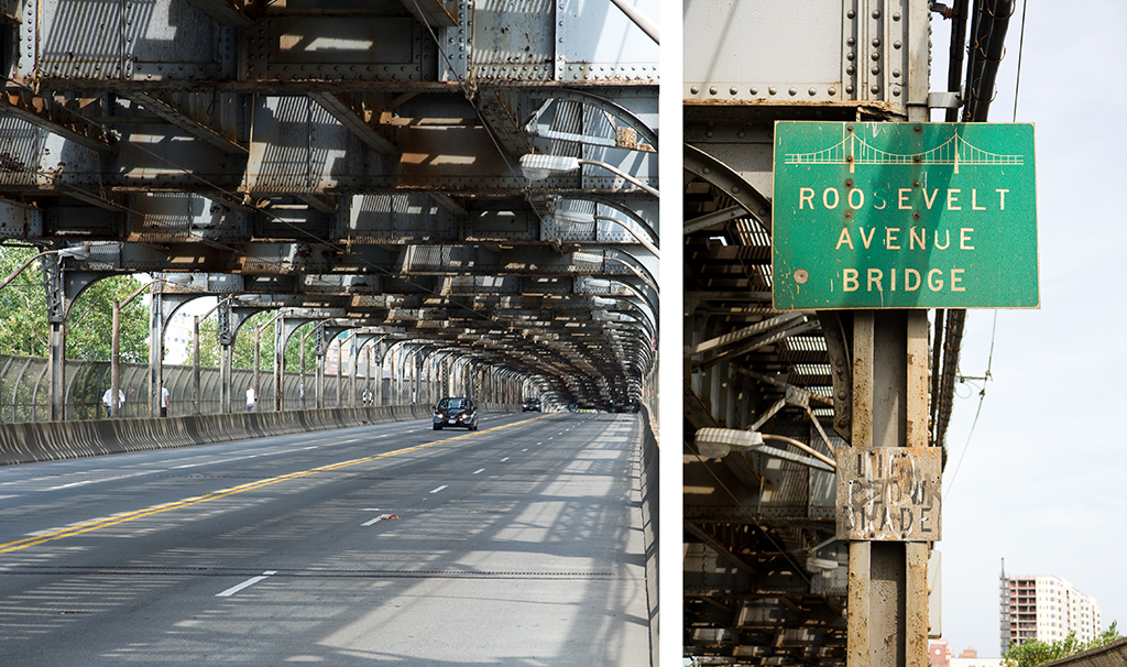
Carries: 4 vehicular lanes, 2 sidewalks, IRT 7 subway
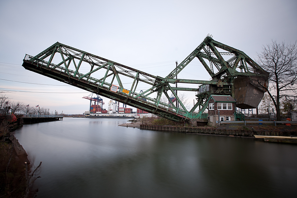
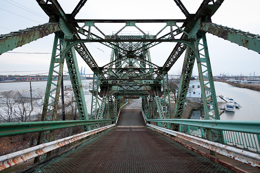
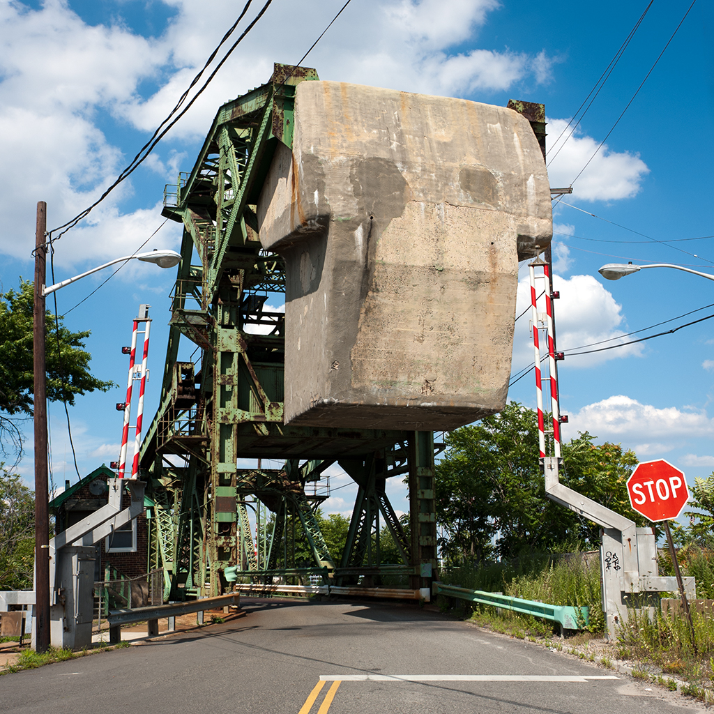
Design: double-leaf bascule
Date opened: May 14, 1927

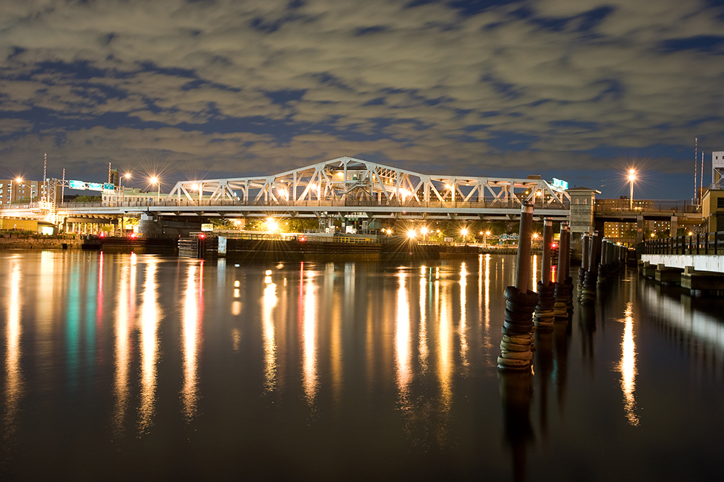
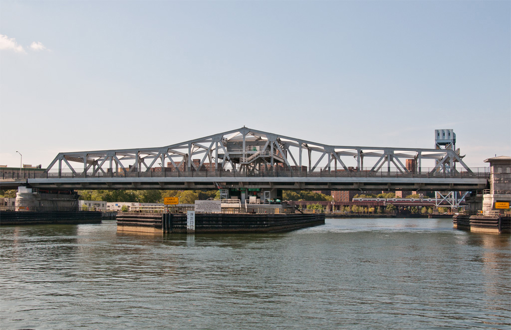
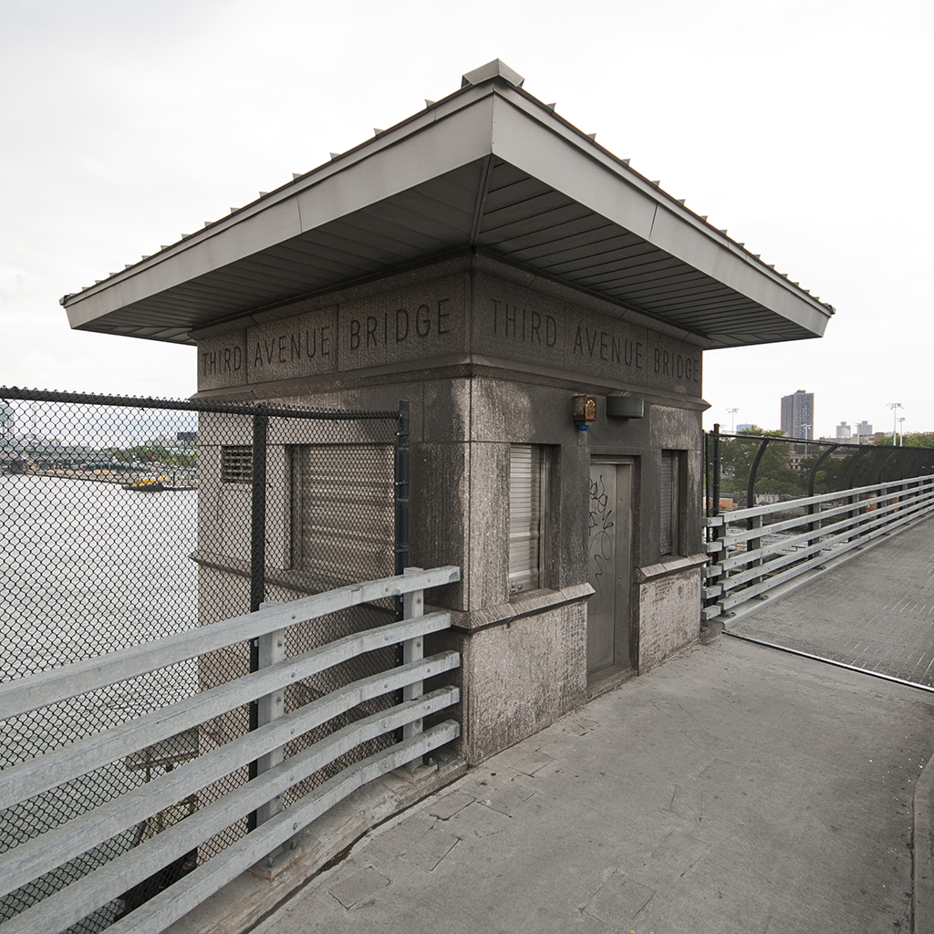
The Roosevelt Avenue Bridge is a double-deck, double-leaf bascule movable bridge over the Flushing River in northeastern Queens. It carries four lanes of Roosevelt Avenue and two sidewalks on its lower deck, and three tracks of the IRT Flushing / 7 train line of the New York City Subway on its top.

Planning

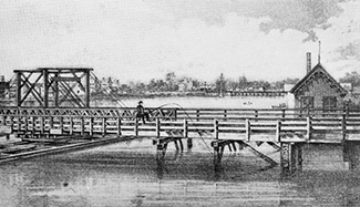
Surveying for the bridge began in 1913 as part of an extension of the Interborough Rapid Transit Company’s Woodside and Corona line. The original plan had the line mapped out between 42nd Street in Manhattan and Prime Street in Corona, with the extension reaching out to the village of Flushing, with a possible further extension to Little Neck at the city line. The line reached Corona in 1917, but United States involvement in World War I prevented further construction. Financial problems after the war delayed progress still until 1921, when city engineers began negotiations with the US War Department concerning what type of structure the city could build to cross the Flushing River. The War Department, which had jurisdiction over all navigable waterways and their crossings in the country at that time, denied a request by the city to be allowed to build a simple fixed bridge across the river on account of it being an obstruction to river traffic. A tunnel was briefly considered, but was decided against when cost estimates for it reached $2,500,000, more than the city was willing to pay. The War Department suggested the city build a bascule bridge, and officials relented.

Construction

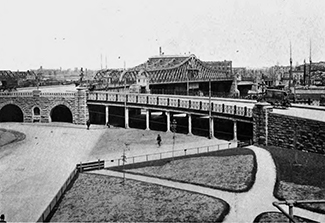
Groundbreaking for the bridge was held on April 21, 1923 in a ceremony attended by Mayor John Hylan and Maurice E. Connolly, Borough President of Queens. Construction began soon after, though many delays occurred due to a recurring problem with the foundations of the bridge settling in the deep mud on the banks of the river. On May 14, 1927, the bridge was opened to pedestrians and a bus line was established between downtown Flushing and Willet’s Point Boulevard station, the temporary terminal of the line while the foundation issues were being resolved. Train service would not begin across the bridge until January 21, 1928, with a special train for city officials making the inaugural run from Time Square to the new station in Flushing. The extension to Little Neck has yet to be built.

view from the walkway
Roadway and sign

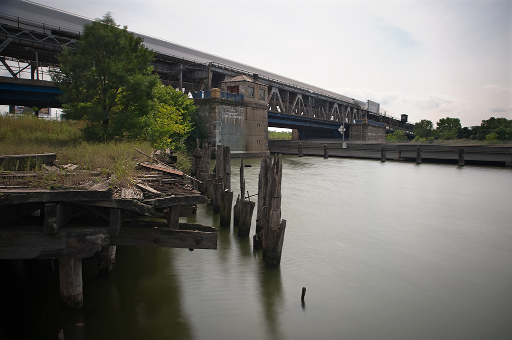
The final cost of the bridge was $2,640,000, more than the estimated cost of a tunnel under the river, even when adjusted for inflation. Despite the additional cost the city was required to pay for a movable bridge, the need to keep the river open to navigation did not last long. When construction of Flushing Meadows Park was under way in 1939, park engineers realized a dam was needed to keep the tides of the East River from inundating the low-lying fields. The Long Island Railroad, which runs just a few hundred feet upriver from Roosevelt Avenue, agreed to replace the swing bridge they owned over the river with a combined embankment and tidal gate on top of which they would continue to operate their trains. With no docking facilities in place between the two structures, navigation of the Flushing River effectively ended at the Roosevelt Avenue bridge. In 1961, construction of the northern extension of the Van Wyck Expressway began, and the route of the highway was driven directly through the navigation channel of the bridge, supported over the river by concrete piers. The operating mechanisms and bridge tender’s controls were finally removed at that point, and the bridge has not opened since.

Design

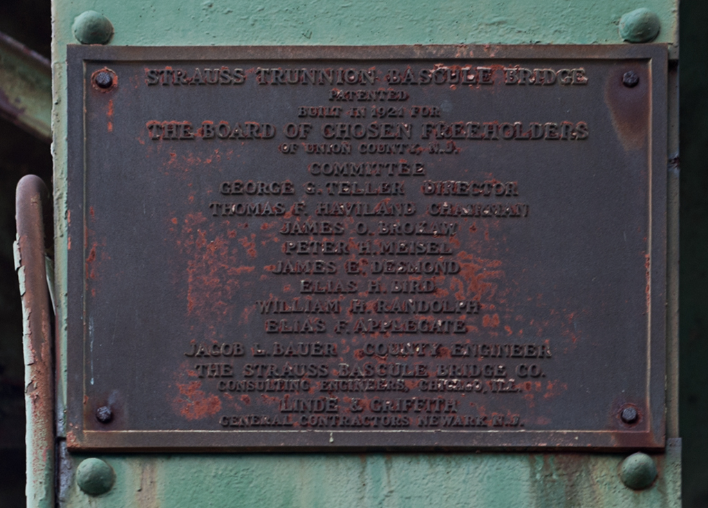
The Roosevelt Avenue bridge was the largest trunnion bascule bridge in the world when it was completed. It was designed by Edward A. Byrne and Robert E. Hawley of the NYC Department of Plants and Structures, and built by the Arthur McMullen Company of New York. The channel of the river at the point of the bridge is only 70 feet wide, but because of the skew of the route over the river, the clearance between the bridge piers is 162 feet. Together, the lift leaves are 153 feet long, and each weighs approximately 4 million pounds, supported by a truss structure 25 feet 6 inches deep. The piers that support the leaves are of poured concrete construction, with granite blocks covering the facings exposed to the water. Each pier measures 92 feet by 118 feet, and contains a large hollow space inside to accommodate the movement of the bridge’s counterweights.

Future

In January, 2010, the NYC Department of Transportation announced plans to rehabilitate the bridge starting in 2012. Years of neglect have resulted in a need to replace the road deck, repaint and repair rust on the steel truss and approach structures, and repair deteriorating concrete. The city also plans widen the sidewalks from 8 to 10 feet and establish bike lanes within them. The project is expected to be finished in 2015.

Update (04/29/2015): Rehabilitation has been delayed and is now expected to begin in mid-2015 with an end date to be determined.

[ continue to references ]

South Front Street Bridge

South Front Street Bridge in open position

Crosses: Elizabeth River
Location: Carries South Front Street over the Elizabeth River near its outlet into the Arthur Kill, Elizabeth, NJ [satellite map]
Carries: 1 vehicular lane, 1 pedestrian sidewalk
Design: Strauss heel trunnion bascule bridge
Date opened: 1922

The South Front Street Bridge is located just before the Elizabeth River opens up into the Arthur Kill, along the waterfront in Elizabeth, NJ.

Plans for a movable bridge at South Front Street were approved on July 3, 1916 by the Secretary of War. A riparian grant (a deed granted for normally state-owned tidelands) was obtained for $260 from the state of New Jersey in 1917, officially allowing the bridge to be constructed by the City of Elizabeth. The American Bridge Company built the bridge, beginning in 1920; it opened to traffic in 1922.

Design

The South Front Street Bridge is a Strauss trunnion bascule bridge; it was designed by the Strauss Bascule Bridge Company, headed by Joseph Strauss in Chicago. Strauss patented the Strauss bascule design of the trunnion type, which open on a fixed axle. The South Front Street Bridge is a heel trunnion, which is a variation on the design, and is the only remaining road-carrying bridge of its type in New Jersey (though there are still several heel trunnion railroad bridges in the state). The heel truss has the advantage of taking up less space than traditional bascule designs, thus requiring less construction material.

The bridge is skewed, so its trusses are of different lengths: 131’ 8” on the west side and 116’5” on the east. The bridge’s substructure and massive counterweight are made of concrete, which has undergone repairs several times. A small brick bridge house is located adjacent to the bridge; inside are the controls. The machinery which operates the bridge is on the bridge above the road; it consists of original gears and electric motors which were added in 1940.

The bridge was originally built with a wooden roadway, but it was replaced with a steel deck in 1956. The pedestrian walkway is still constructed of wood, though not the original wood deck. The bridge underwent significant repairs in 1976.

bridge deck
View from the bridge deck; the Chemical Control site is to the left.

The Elizabeth River’s Decline

The Elizabeth River was once home to six movable bridges, to accommodate its heavy use by ocean-going vessels. However, shipping on the river came to an end soon after the the 1951 opening of the New Jersey Turnpike. The U.S. Corps of Engineers deemed that three of the movable bridges would become fixed later in the 1950s. Another of the six (the Baltic Street Bridge) had been left isolated by the Turnpike construction, and it was sold for scrap in 1954. The South First Street Bridge, built in 1908, suffered a fire in the bridge tender’s house in 1984. With its control center gone, it permanently remained closed. The bridge was replaced completely in 2010. This leaves the South Front Street bridge as the only remaining operational drawbridge in all of Union County.

Only a few hundred feet of the Elizabeth River are still navigable, so the waterway only sees vessels designed for recreation, not industry. Still, a 2003 publication about Elizabeth estimated that the bridge was opened an average of 2,000 times a year [1].

Contamination Next Door

The bridge sits adjacent to the former site of the Chemical Control Corporation, a notorious part of New Jersey’s history with chemical dumping. The property, bordering on the southeastern end of the bridge, was originally marshland, but was filled in when Elizabeth developed much of its land for industrial use during the latter half of the 19th century. The Chemical Control Corporation was in operation from 1970 to 1978 as a disposal facility for hazardous waste. The company, which began as a legitimate business, became more notable for its practice of disposing of waste illegally, and was cited repeatedly until the state forced it to close in March of 1979.

concrete counterweight

The New Jersey Department of Environmental Protection began cleanup at the site shortly after; about 400,000 gallons of bulk solids and liquids, infectious and radioactive waste, and explosive liquids were removed. In May, upon hearing that the cleanup had uncovered nitroglycerin and other potential explosives, Elizabeth’s mayor Thomas G. Dunn declared a state of emergency in the area a half mile around the site, restricting pedestrian and vehicular traffic. The cleanup and restrictions were fortunate, because on April 21, 1980 there was an explosion at Chemical Control which led to a fire of spectacular proportions: drums of waste were launched into the air and exploded over the Arthur Kill; it took 10 hours to get the blaze under control but firefighters spent weeks at the site. NJDEP continued its cleanup and investigations after the fire; unfortunately, many of the records of which companies were connected to which hazardous materials were stored on-site and therefore lost.

In October 1981, it was proposed that the Chemical Control site be included on the National Priorities List of Superfund sites; its inclusion was finalized in September 1983. Cleanup continued, and a 1985-6 study found that contaminants including PCBs, naphalene, and benzene were still present in the soil, groundwater, and surface water. A slurry wall was later constructed around the site and anchored into a layer of clay under it; this helped stop groundwater contamination. A 2003 study of the site found that in general the contaminants which were contained during the cleanup remain contained, though it was noted that small area around the site may still be somewhat contaminated (one of three sampling stations still showed high levels of vinyl chloride and 2-butanone [2]).

plaque
plaque

The Bridge’s Future

In 2008, it was announced that the New Jersey Department of Transportation would supply $330,000 to repair the bridge. Work was done to reinforce the deck. The city was granted a further $1,000,000 in 2010 for more rehabilitation work. However, due to ongoing structural concerns, the bridge has been left in the open position since March 4, 2011; traffic is rerouted to the new South First Street Bridge. A study is underway to determine whether the bridge can be rehabilitated or not. The bridge remains eligible for the State and National Registers of Historic Places.

[ continue to references ]

Third Avenue Bridge

Third Avenue Bridge
Third Avenue Bridge

Crosses: Harlem River
Connects: Third Avenue between Mott Haven, the Bronx and Harlem, NY [satellite map]
Carries: 5 Manahattan-bound vehicular lanes, 2 pedestrian sidewalks
Design: swing bridge
Date opened: 2004
Postcard view: “Harlem River, N.Y. City”

The Third Avenue Bridge is a swing bridge over the Harlem River, connecting Third Avenue in Manhattan with Third Avenue in the Bronx. It is the fourth bridge to stand at that location.

In 1774, Lewis Morris received permission to build a bridge to connect a proposed road through Harlem with a road leading to the Morris family’s estate, Morrisania, and the village of Eastchester (both are now neighborhoods located in the Bronx). Though a ferry had once operated between Manhattan and the Bronx just east of the proposed site of the crossing for a few years in the late 1600s, the only way for people to travel between the two at the time of Morris’ proposal was by either King’s Bridge or Farmer’s Bridge, both of which were located at the far northern tip of Manhattan. Morris’ bridge would cut the traveling distance between his estate and the southern end of Manhattan, the core of the city at the time, by nearly 12 miles.

Coles Bridge

Nothing was done about the bridge, however, until the end of March 1790, when a refined charter was given to Morris to build a drawbridge at least 12 feet wide to accommodate river traffic. Morris was also given permission to charge tolls on the bridge for a period of 60 years, after which ownership of the bridge would pass on to the state. Such arrangements were common at the time as an enticement for private entities and individuals to invest in public infrastructure.

Coles Bridge, opened 1797 (Source: Proceedings, Municipal Engineers of the City of New York)

Also common at the time were delays concerning large projects such as this. Nothing concerning the bridge is mentioned in the city’s legislative archives until March 1795, when Morris sought permission to transfer his charter to a business partner and family friend named John B. Coles. The new charter was approved with a modification allowing Coles to build the bridge on top of a dam in order to a establish a water-powered mill at the site. In early 1797 the Coles Bridge, as it came to be known, a simple wooden structure with a turntable draw span, was opened, though Coles apparently never got around to building a dam underneath it. The route over the bridge, consisting of a newly constructed Middle Road (now roughly Eighth Avenue and Central Park West) in Manhattan and what came to be known as Coles Road (now Third Avenue and Boston Post Road in the Bronx) quickly became more popular than the King’s Bridge or Farmer’s Bridge route, in spite of the fact that Coles had inherited and taken advantage of Morris’ right to charge tolls while the uptown crossings were both free to use.

The Harlem Bridge

On April 1, 1858, in accordance with the original charter’s stipulation and the State Legislature’s Chapter 774 of the Laws of 1857, ownership of Coles Bridge passed from the Coles family to the state government. By that time, the bridge had fallen into such a bad state of repair that nothing could be done to save it, according to the Commissioners of Harlem Bridge, a group consisting of New York and Westchester officials convened specially to oversee the takeover of the bridge by the state. In June 1860, the Commissioners made an official inspection of the bridge in anticipation of a reconstruction project. They found the superstructure in an advanced state of decay and “the piers destroyed by the ravages of the worm” [1] (the worm in question, teredo navalis, is not actually a worm but a mollusk, commonly known as the shipworm or marine borer. It is still a serious problem in the city, with many millions of dollars budgeted for the reconstruction of waterfront piers, highways, and high rise foundations due to its highly efficient method of consuming submerged wooden pilings).

The Harlem Bridge, opened 1868 (Source: New York Public Library)
Harlem Bridge, opened 1868 (Source: New York Public Library)

The official decision to rebuild the bridge came soon after, and work began in August 1860. Erastus W. Smith, a New York mechanical engineer with many years of experience running municipal water works and ocean liner systems was named as Chief Engineer of the project. The original plans for the bridge called for a series of simple through truss approach spans with a through truss swing span atop a turntable. Smith decided instead to build the bridge with arched tubular truss spans constructed of wrought iron, giving the bridge a gracefully curved profile in comparison to the original boxy design. The old span was kept in place as the new bridge was built just west of it. The piers for the new bridge consisted of a combination of six foot and eight foot diameter cast iron cylinders, sunk into the river bed by pneumatic force, one of the earliest instances of the use of compressed air for bridge construction in the country. The pier sinking and foundation work were completed by the New York firm of Roach & Edwards. The superstructure of the bridge was constructed by the Trenton Locomotive Machine Manufacturing Company of New Jersey. After 8 years of work, the still incomplete bridge, called the Harlem Bridge, was opened for public use on October 16, 1868. The bridge measured 526 feet long by 52 feet wide, including a 218 foot long swing span that operated under the force of water supplied by a Croton water main. Shortly after it opened, a horse car railroad was established over the bridge by the Harlem Bridge, Morrisania and Fordham Railroad Company. Horses would be used on the bridge until 1891, when they were replaced by a an electric propulsion system with power provided by overhead wires.

The Third Avenue Bridge

The Harlem Bridge did not last long, however. After several years, parts of the bridge began to fall apart. The cast iron piers began to crack and the wheels under the turntable had to be replaced multiple times after breaking into pieces. The water powered engine was found to be too sluggish to keep up with the demands of road and river traffic and had to be replaced with a steam engine. In 1882, jurisdiction over all underwater land surrounding the city passed on to the US Government, which had plans to improve the waterways of the city. in 1890, the government passed the Rivers and Harbors Act which specified, among other changes, that all bridges over the Harlem River be raised in order to provide 24 feet of clearance above high water. The Harlem Bridge only provided 5 feet of clearance over the river. Shortly after, the city’s Department of Public Works, which had jurisdiction over the bridge at the time, brought forth a bill in the state legislature asking for authorization to replace the bridge with one that would comply with the new law. The bill was approved, and authorization came in the form of Chapter 413 of the Laws of 1892.

Third Avenue Bridge (Source: Report of the Commissioner of Bridges, 1904)

The Harlem Bridge was closed on June 20, 1894, with traffic diverted to a temporary bridge while the new Third Avenue Bridge, as it would be called, was being built. The new span was constructed as a swing bridge, with a swing span operating under steam power. The span was made with steel provided by the Phoenix Iron Works Company of Phoenixville, Pennsylvania. The span was 300 feet long and was composed of a large through truss structure with curved upper chords terminating at a sharp apex. It was designed by Thomas C. Clarke, the consulting engineer assigned to the project by the Department of Public Works. It was opened on August 1, 1898 with the blowing of its warning whistle, which was soon joined in by the blowing of whistles from nearby boats, trains and factories. It was the largest and heaviest bridge of its type in the world at the time. The bridge had room for two walkways and a roadway containing two sets of trolley tracks laid down by the Union Railway Company, the successor to the Harlem Bridge, Fordham and Morrisania Railway Company during the construction of the bridge. The tracks would remain in place until 1953 when the Third Avenue Elevated train line was demolished. The tracks were then converted into automobile lanes.

Replacement Third Avenue Bridge, opened 2004

Replacement

The Third Avenue Bridge served the city well until the night of November 7, 1999, when a two alarm fire broke out on the wooden fender surrounding the swing span, closing the bridge for several days. in 2001, the city Department of Transportation, which now has jurisdiction over the bridge, began a $119 million reconstruction of the Third Avenue Bridge as part of a nearly $1 billion program to rehabilitate or replace all of the movable Harlem River Bridges. The new bridge, a swing span like all of its ancestors, was designed to visually mimic as closely as possible the span it replaced, albeit with more modern construction techniques and materials. It carries two sidewalks and five lanes of Manhattan-bound traffic. It opened in 2004.

bridge house
bridge house

[ continue to references ]