Midtown Bridge

Midtown Bridge from Oscar E. Olsen Park in Bogota, 2015

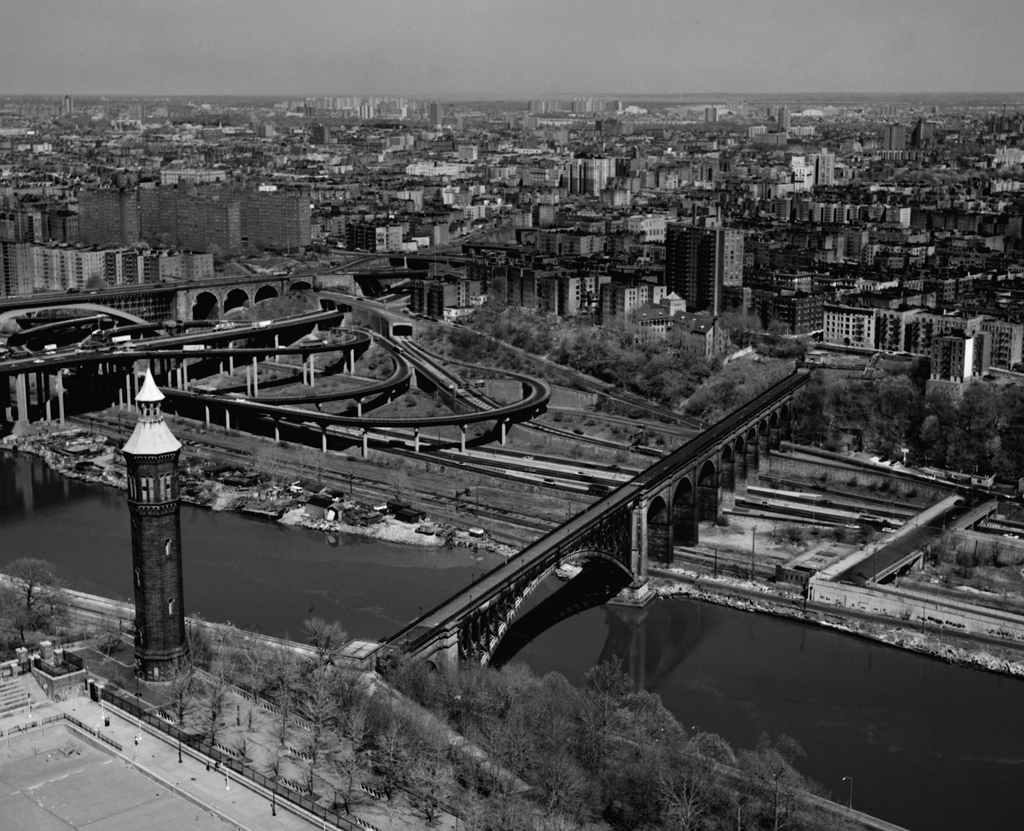
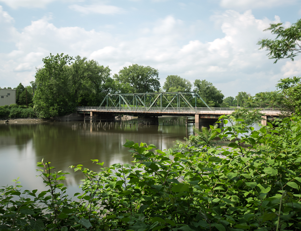
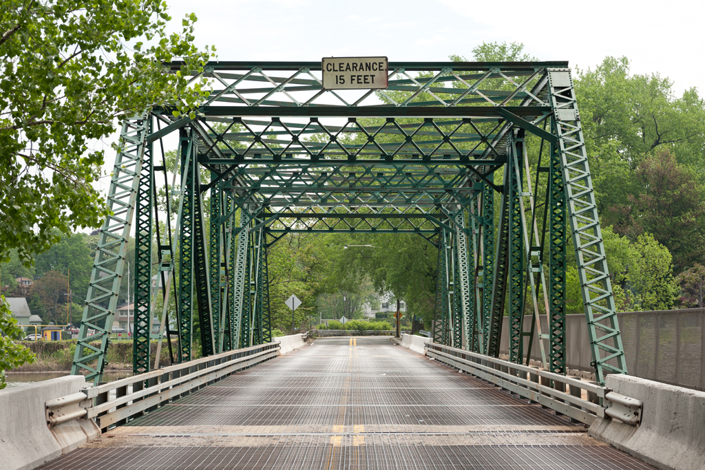
Crosses: Hackensack River
Connects: Hackensack and Bogota, NJ [satellite map]
Carries: 2 vehicular lanes, 1 sidewalk
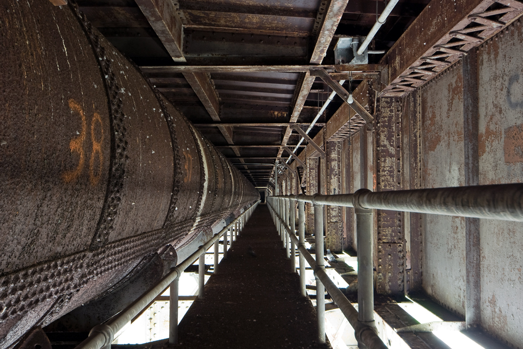
Design: (former) swing bridge, fixed into place in 1984
Date opened: 1900

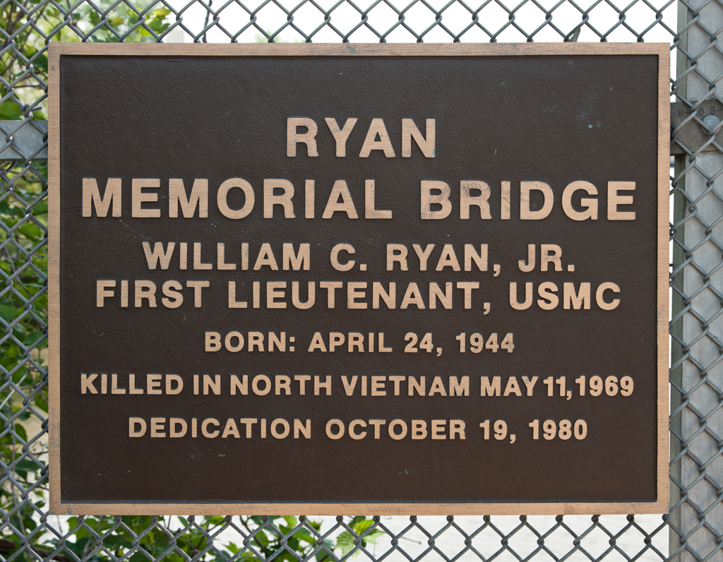
The Midtown Bridge, also known as the Salem Street Bridge and William C. Ryan Memorial Bridge, is a fixed through truss bridge that was formerly a swing bridge. It spans the Hackensack River, connecting Hackensack and Bogota in Bergen County, New Jersey.

Midtown Bridge-03
Passaic Rolling Mill Co. founder’s mark on steel beam

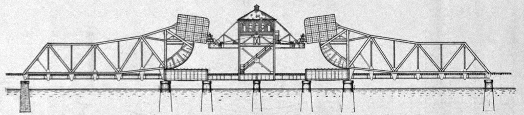
The bridge was originally built in 1900 by F.R. Long and Company as a trolley bridge for the Bergen County Traction Company. Steel for the bridge was provided by the Passaic Rolling Mill Company of Paterson, NJ. The bridge’s original design was a through Pratt truss swing span on a stone center pier and it carried two sets of tracks. The Bergen County Traction Company had been formed in 1894, and opened in 1896, connecting ferry passengers traveling from Manhattan to Edgewater to trolley lines to Fort Lee, Leonia, Englewood, Teaneck, Bogota, and Hackensack. The lines were consolidated in 1900 into the New Jersey and Hudson River Railway Company and later sold to the Public Service Corporation of New Jersey in 1910. The Bergen Division of the Public Service Railway continued to carry trolleys over the Hackensack (a 1937 image can be seen in Figure 139 (page 189) of Streetcars of New Jersey: Metropolitan Northeast [1]).

However, with the rise of the automobile, transportation was changing, and trolley routes began to be replaced by buses. By 1938 all trolleys had been discontinued in Bergen County; the bridge’s tracks were replaced with a steel deck and in 1940 the Midtown Bridge began carrying vehicular traffic. It continued to operate as a swing bridge until a rehabilitation project in 1984, when it was fixed in place and its machinery was removed. In 1980, the bridge was given the additional name of “Ryan Memorial Bridge,” named after Bogota resident and U.S. Marine Corps Lieutenant William C. Ryan, who was killed in North Vietnam in 1969.

Steel deck, 2010
Steel deck, 2010
Ryan Memorial Bridge plaque

The Midtown Bridge has only recently been notable for being in need of repair. It was shut down for several weeks in 1998 by the Department of Public Works so that emergency repairs could be made to its steel joints. The issue was described by county engineer Robert Mulder as “an ongoing problem that needs to be permanently fixed” [2]; however, that fix has been continually delayed. A project to rehabilitate the Court Street Bridge, another former swing bridge in Hackensack downriver from the Midtown Bridge, meant that it was closed from 2010-2012, with much of the Court Street Bridge’s traffic diverted to the Midtown Bridge during that time. On October 17, 2013 the Midtown Bridge was shut down for emergency repairs again; Bogota’s Council President and Office of Emergency Management coordinator Tito Jackson had noticed a large separation in the bridge’s metal decking at its joints [3]. The current plan is to replace the aging span with a bridge with a concrete deck. Bergen County is home to a number of bridges in need of major repair or replacement, so there is no timetable for the project as of yet.

[ continue to references ]

High Bridge

High Bridge walkway, 2015

Crosses: Harlem River
Connects: Manhattan and the Bronx [satellite map]
Carries: Pedestrian/bike path; formerly carried the Old Croton Aqueduct in its interior
Design: Stone arch bridge with steel arch section
Date opened: 1848
Postcard views: bridgesnyc.com/postcards

The High Bridge, also known as the Aqueduct Bridge, opened in 1848 and is the oldest extant bridge in New York City. The bridge was built to carry the Croton Aqueduct into New York City from upstate New York. It crosses the Harlem River, connecting High Bridge Park in Manhattan with the Bronx near West 170th Street.

Need for Water

Providing a supply of drinking water has long been a problem for the island of Manhattan. Surrounded by brackish water (an undrinkable mixture of salt and fresh water), in its early days, the city got its water from wells, cisterns, and natural springs. However, the city was constantly growing and expanding northward; it grew especially quickly in the years following the Revolutionary War. The limited sources of fresh water available became polluted and diseases such as yellow fever were rampant. The city’s first cholera epidemic began in 1832 and infant mortality soared. The wealthy paid to have their water delivered, but the poor, living in overcrowded, unsanitary conditions, had no options other than to drink polluted water. In 1832, Colonel DeWitt Clinton, of the U.S. Army Corps of Engineers, proposed building an aqueduct to supply the city with water from the Croton River, north of the city in Westchester County.

High Bridge as originally constructed, ca.1900s

High or Low

Lettering on stone pier, Bronx, 2009

A temporary water commission was created in 1833 with civil engineer David Bates Douglass appointed as chief engineer to plan for a new water supply. Douglass proposed a high stone arch bridge across the Harlem River as part of his plan to carry water 40 miles from Westchester to the Croton Distributing Reservoir, built between 40th and 42nd Street in Manhattan (a site currently occupied by Bryant Park and New York Public Library’s main branch, the Stephen A. Schwarzman building). The Water Commission was formally established in 1834, and more surveys were done, including one by John Martineau, which included a low bridge which would cost less but block more of the river. Martineau’s plan was initially approved in 1835. On December 16 of that same year, the Great Fire of New York began in a Merchant Street warehouse; the city was ill-equipped to fight it and the need for a sufficient water supply was yet again in the headlines. The Board of Water Commissioners, favoring a low bridge, quietly replaced Douglass with John Bloomfield Jervis in 1836; Jervis was well-known as chief engineer of the Erie Canal. Jervis surveyed and planned for the low bridge, but opposition came from the Board of Aldermen in 1838, with the argument that the low bridge would impede navigation on the Harlem River. At the time, the river was already obstructed–Macomb’s Dam to the south and mills in the Kingsbridge section of the Bronx were both impassible. Though a decision had yet to be reached, the Water Commission began to build a low bridge across the Harlem River in July, 1838. That work was halted in May, 1939 when the State Legislature stepped in, giving two choices: a high bridge (allowing at least 100 feet of clearance under the bridge) or a tunnel under the river. Jervis drew up plans and construction began in August, 1839.

High Bridge Design

Water pipe inside stone portion of High Bridge, 2009
Water pipe inside stone portion of High Bridge, 2008

The bridge built consisted of 15 circular stone arches and had a clear height of 114 feet at high tide. It was meant to look like Roman aqueducts, though many modern innovations were employed. One was making the piers hollow to lessen dead weight, at the same time allowing water to drain back to the river. An opening gala for the Croton Aqueduct was held on July 4, 1842, and a celebratory parade followed on October 14. All this celebration was somewhat premature in terms of the High Bridge, as it wasn’t fully completed until 1848; temporary pipes carried the water until it was finished. The city continued to grow, as did its water needs. By 1850, the two original 36-inch pipes in the bridge were seen as inadequate, but it took until 1861 to install a third, 90-inch pipe. Between 1866 and 1872, the 200-foot-tall High Bridge Water Tower (also designed by John B. Jervis) and a seven acre reservoir were built to allow water to flow to residents in Manhattan’s higher elevations. It, along with a reservoir Soon, the Croton Aqueduct itself was unable to keep up with the city, and more aqueduct projects were envisioned. The New Croton Aqueduct opened in 1890, followed by the Catskill Aqueduct system, partially opened in 1916 and fully completed by 1924.

Threat of Destruction

Catwalk under steel arch span and water pipe, 2009
Catwalk and water pipe under steel arch span, 2008

World War I brought changes and threats to the High Bridge’s continued existence. On February 3, 1917, the High Bridge Aqueduct was closed. It was feared that wartime saboteurs could destroy the aqueducts and flood the city [1]; since the city already had two newer aqueducts to guard, the Old Croton was shut down so it wouldn’t have to be patrolled. It was eventually put back into service, but was never again seen as necessary. The Harlem River was used extensively for shipping during World War I and the High Bridge’s piers came to be viewed as a hazard–obstructions that had existed during the bridge’s construction, such as Macomb’s Dam, had been dealt with long ago (the dam had been replaced by a swing bridge in 1861). The Army Corps of Engineers ordered the removal of the piers that were in the river, and that turned into a suggestion by the city to simply demolish the bridge altogether. New York City’s citizens as well as numerous professional engineering organizations protested, and debates followed for the next several years. In March of 1923 it was decided that the bridge would be spared so long as a larger channel could be opened for navigation [2]. Plans for a cantilevered arch design were approved by the Municipal Arts Commission in July 1925. A New York Times article stated that, “from a distance, the projected single span will harmonize with the Washington Bridge” [3]. Five of the original arches were replaced with one steel span in 1927 [4]. The replacement steel arch has never evoked the same feelings as the stone arches, as Christopher Gray described in a 2013 New York Times article:

To see the bridge from a distance, the engineering pilgrim can brush by the piers at speed on the north- and southbound Major Deegan Expressway. But a more contemplative view can be had from Depot Place, a tiny stub off Sedgwick Avenue just south of the bridge. There, the granite piers start out from the Bronx shore in perfect majesty, only to be brought to an unseemly halt at the river. [5]

High Bridge and Water Tower, ca. 1984 (Source: Historic American Engineering Record, NY-119-10)

Closing of the Old Croton Aqueduct

Once both the New Croton Aqueduct and Catskill Aqueduct had been opened, the original Croton Aqueduct essentially became obsolete. The Croton Distributing Reservoir was torn down in the 1890s, but the “Old” Croton Aqueduct was still used to fill the Croton Receiving Reservoir, located in Central Park, until 1940, when Commissioner of Parks and Recreation Robert Moses had it taken out of service. The reservoir was filled and is now Central Park’s Great Lawn.

High Bridge walkway, closed (2009)
High Bridge walkway (closed), 2009

Closing of High Bridge

High Bridge remained open as a pedestrian path, though water had long ceased to flow within it. Rumors abound as to the exact reason for the eventual closure of the path, but a common one is that someone taking a Circle Line cruise up the Harlem River was either hurt or killed by rocks flung from the bridge. A New York Times article from April 21, 1958 states that:

Four passengers on a sightseeing boat were hurt yesterday when a gang of juveniles hurled sticks, stones and large pieces of brick from a bridge as the ship passed below. The bombardment started just as the Circle Line’s excursion boat No. 8 steamed into the shadow of High Bridge on the Harlem River. [6]

Being hit from above on the Harlem River was nothing new; in 1904 a group of oarsmen asked for police protection from “stone-throwing hoodlums who infest the various bridges over the Harlem River” [7]. Regardless of the reason, the pedestrian path was closed in the 1970s. The High Bridge was designated a New York City Landmark by the Landmarks Preservation Commission in 1970 [8]. It was also made a National Historic Civil Engineering Landmark in 1975, and a National Historic Landmark in 1992. Designations aside, the bridge had fallen into a state of disrepair; Sharon Reier lamented in 1977 that “the lofty structure is now fenced off with tangles of barbed wire reminiscent of the Berlin Wall.” [9]

Reopening

The bridge sat unused for many years, other than by those brave enough to scale its barbed wire fence. Pedestrians crossed the Harlem River on the Washington Bridge several blocks to the north, a busy bridge with a narrow pedestrian lane. In 1995, 10-year-old homeschooled Maaret Klaber attended a community board meeting and asked the park committee to reopen the walkway [10]. It would be a long wait, but in 2006 the Department of Parks and Recreation announced plans to reopen the bridge, though many hurdles still remained before work could begin. Advocacy groups, including the Friends of the Old Croton Aqueduct and the High Bridge Coalition, pushed for its reopening and work began in 2012, based on a 2011 New York City Parks Department plan [11]. The restoration, financed by the city and supplemented by Federal Highway Administration funds, cost over $60 million. The bridge’s stone joints were re-mortared, its brick walkway was cleared of plants and repaired, its cast-iron fencing restored (and 8-foot-high safety netting was added outside of the decorative fencing), new lighting and ramps were added, and its steel arch was repainted. After more than 40 years, the bridge reopened to the public on June 4, 2015.

[ continue to references ]

Central Railroad of New Jersey Newark Bay Bridge

Newark Bay Bridge piers
Central Railroad of New Jersey Newark Bay Bridge piers, 2015

Crossed: Newark Bay
Connected: Elizabeth and Bayonne, NJ [satellite map]
Carried: 4 railroad tracks (Central Railroad of New Jersey)
Design: Vertical lift bridge
Date opened: November 27, 1926
Date demolished: 1980-1988

The Central Railroad of New Jersey Newark Bay Bridge was a two-mile-long vertical lift bridge which consisted of two spans that each carried two railroad tracks. The bridge crossed two shipping channels in Newark Bay and therefore had two lift spans, each with two draws that could be moved independently. The bridge carried both passenger and freight trains.

Previous Bridges

The Central Railroad of New Jersey, also known as the Jersey Central (and often shortened to CNJ), was a railroad that had its beginnings in the 1830s. Originally called the Elizabethtown and Somerville Railroad, it connected Elizabethport and Elizabeth, NJ in 1831 before extending outward to Somerville in 1842. It was renamed the Central Railroad Company of New Jersey in 1849, as it continued its expansion by building new track and acquiring other railroads; by 1852 it reached Phillipsburg, on the Delaware River. The first bridge built by the CNJ across Newark Bay was a wooden trestle with a steel swing span that opened on a central pier. It carried two tracks and opened in 1864; this line ended at the Central Railroad of New Jersey Terminal, located on the Hudson River waterfront in what is now Liberty State Park in Jersey City (the original 1864 building was replaced in 1889 with the Romanesque structure which still stands).

A double Scherzer Rolling Lift bridge replaced a swing bridge in 1904. (Source: Engineering-News Record, Vol. 49, No. 9)
A double Scherzer Rolling Lift bridge replaced the 1864 swing bridge in 1904. (Source: Engineering-News Record, Vol. 49, No. 9)

In 1903, work was begun on a replacement for the wooden bridge. Maritime traffic had increased steadily, and the volume and size of the trains crossing the bridge had also grown. The swing span had to open frequently and the CNJ also wanted to plan for an expansion of the crossing from two tracks to four. The design selected consisted of two Scherzer Rolling Lift spans; a key advantage over the swing bridge was that the bridge would not need to open fully to allow passage of barges and other low ships. The two-track sections could be expanded to four by building an additional span with identical Scherzer Rolling Lifts next to the existing spans. The west leaf of the movable span was floated into place on February 14, 1904 [1] and followed by the east leaf a few months later. The new span was seen as a vast improvement over the wooden trestle.

From Newark Meadows to Port Newark

However, the character of Newark Bay continued to change. The city of Newark began dredging the shallow Newark Meadows during the 1910s to create an additional shipping channel, which later became Port Newark (it is now known as the Port Newark-Elizabeth Marine Terminal). During World War I the U.S. government used Port Newark to station troops. The Port Authority of New York and New Jersey was formed in 1921 and was followed by the Rivers and Harbors Acts of 1922, which authorized the creation of even more shipping channels. As the crossing closest to the new facilities and the longest crossing, the bridge came to be seen as a huge obstruction to the growing port [2]. Authorities in Newark were in favor of demolishing the bridge altogether and replacing it with a tunnel (which wouldn’t obstruct marine traffic at all). Cost was an issue; a tunnel was estimated at $100 million whereas a replacement bridge would cost $9 million. Proposed by the CNJ in 1922, the replacement bridge, of a vertical lift design, would have two spans (200 feet and 125 feet wide) that would raise for a maximum clearance of 135 feet above the water; they would replace the Scherzer spans which were 85 feet wide each. U.S. Secretary of War John W. Weeks decided in favor of a vertical lift bridge in December of 1922 [3]. However, that was not the end of opposition to the bridge. In November, 1924 a case was brought to the Supreme Court against the CNJ by the state of New Jersey (led by Newark and Jersey City), questioning the right of a railroad to build across a state’s navigable waters [4]. On March 2, 1925 the Supreme Court decided in favor of the railroad [5] and plans to replace the bridge moved forward.

Vertical Lift Bridge

Vertical lift draws in the open position, looking north (Source: Historic American Engineering Record, NJ-37-42)

The Central Railroad of New Jersey sped construction of the new bridge as soon as approval had been granted. The bridge’s designer was John Alexander Low Waddell, a civil engineer well known for his vertical lift bridges. Waddell had moved to New York City in 1920 and was towards the end of a bridge-building career that had begun with a lift bridge in Chicago in 1892-3. The bridge was “believed to be the world’s longest drawbridge” [6]; the bridge’s Chief Engineer Arthur E. Owen declared it to be “the largest drawbridge assembly in the world” [7]. While neither claim was ever definitively proven, it would be hard to argue that the bridge was not impressive. The new spans carried four tracks over Newark Bay; the two shipping channels were crossed by double vertical lift spans that each operated separately from one another. The main difference in the functionality of the new bridge was that its height in the closed position was a minimum of 35 feet above the water, so while the Scherzer Rolling Lift improved upon the previous swing in that it only had to open partially for barges, the new bridge spans only had to open at all for taller ships (allowing the passage of many vessels at all times).

The new Central Railroad of New Jersey Newark Bay Bridge was formally opened on November 27, 1926. It had cost roughly $14 million (far higher than the original $9 million estimate several years earlier). The inaugural train riders included twenty-two “veteran” commuters of the line, most notably a resident of Elizabeth named K.S. Kiggins, who had also attended the first bridge opening in 1864 [8]. New Jersey governor Harry A. Moore, several New Jersey mayors, CNJ president Roy B. White, and many holding high positions at various other railroads were also in attendance. In 1927, W.C. Hope, the passenger traffic manager of the CNJ, released statistics stating the the new bridge had allowed 60% of all marine traffic to pass below it without opening, a steep decline in openings compared to the older bridge [9].

Tragedy

At 10am on September 15, 1958, a CNJ commuter train heading towards Bayonne from Bay Head plunged off the south span, which was partially lifted, and into Newark Bay. The train had proceeded past three stop signals; evidence of mechanical failure was never found and it was believed that the engineer had suffered a heart attack. After a dramatic rescue and recovery effort over the next several days, it was declared that 48 people had died in the tragedy–45 passengers and three crew members. Notable among the dead were former second baseman for the Yankees George (Snuffy) Stirnweiss and John Hawkins, the mayor of Shrewsbury, NJ. Later in 1958, the CNJ announced it would be adding new safety measures: automatic trippers would bring rogue trains to a stop if they ignored stop signals (by using a derail system), and “dead-man” controls would stop trains if the operator released the throttle [10].

Abandonment and Demolition

Deck of vertical lift span (Source: Historic American Engineering Record, NJ-37-16)

The bridge was in for more trouble, however. On a very foggy May 19, 1966, the French freighter S.S. Washington hit the northeast vertical lift span, rendering the two tracks it carried unusable. Furthermore, he overall decline of the railroads was taking its toll on the CNJ; overall ridership was down and in May 1967 the Aldene Plan went into effect. It rerouted CNJ trains departing from Aldene (in Roselle Park, NJ) to Newark rather than over the Newark Bay Bridge. This meant that the only passenger service over the bridge was a shuttle running from Bayonne to Cranford; nicknamed the “Scoot,” its service was very limited. In light of these changes, the damaged span was never repaired.

Use of the bridge continued its steady decline. By the 1970s, CNJ had moved the rest of their freight operation to Elizabeth and only two freight trains a day crossed the span.The Consolidated Rail Corporation (Conrail) took over the operations of the Central Railroad of New Jersey on April 1, 1976 and moved all freight operations to the Pennsylvania Railroad Newark Bay Bridge, north of the CNJ span. The last passenger train crossed the bridge was on August 6, 1978.

The abandoned bridge was deemed a hazard to navigation and an attempt was made to save the bridge by the City of Bayonne. The city was unsuccessful, and on July 11, 1980 explosives were used to partially demolish the bridge. The vertical lift spans and towers fell, engulfed in smoke. The approaches and remaining trestles were removed in 1987-1988, leaving only portions of the piers along the shorelines as visual reminders of the structure that once crossed the bay. The Bayonne Historical Society held a memorial for victims of the commuter train crash in 2008, 50 years after the accident, but other than that the bridge has been largely forgotten. Some remaining portions of the bridge were blasted away as recently as February, 2012 [11]. On the Bayonne waterfront, cormorants and seagulls can be seen roosting on the few crumbling piers that still extend into Newark Bay today.

CRRNJ Newark Bay Bridge piers, 2015
Central Railroad of New Jersey Newark Bay Bridge piers, 2015

[ continue to references ]